I started out at the Otterhole as I always do. Despite the fact that parking at Weis Ecology, and hiking in from the north is probably an easier way to reach the high point, I needed some time myself.
Here is my GPS track, the parking lot is in the bottom left, near the little pond and the road. This is the middle (2nd) parking area along Glewnwild Road, by the border of Bloomingdale and West Milford.

I hiked counterclockwise around this loop you see above.

The rock-hop of the Otterhole. (don't try it in highwater)

The otterhole

Here is where the Highlands trail begins the ascent of Cariss hill

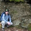
there are some views of Wyanokie Torne mountain behind me

There is quite a lot of mountain laurel forests that you travel through on the summits of these mountains. Some of them can get quite thick.

I actually found some snow!!!!

This is right near the summit. I love these pines.

View from summit of Cariss hill

After heading further up the Highlands trail, here is my first good view of the bald face of the Wyanokie Highpoint. This shot is from yoohoo point

heading my way?

View Southeast from Wyanokie High Point (no shots of me it was too windy)

View East (Windbeam mountain, another of my favorite NJ climbs)

In this shot, you can make out NYC, and just to the left of New York on the horizon, is the triple peaked, Preakness Mountain. My house is just on the other side of this mountain. Also in the mid shot, route 287 is visible as it bridges out over the wanaque valley.

Back on the trail, here is the intersection with the outlaw trail

I didn't take many other shots on the way back to the car. I was going to visit the valley of giants on the north end of Buck Mountain but was running out of time and didn't feel like the full traverse of Buck. I took the green trail through the valley back to the otterhole and back to my car. All together it was 5 miles, and a wonderful day!
NJOY