Hike Balsam Mountain from McKenley Hollow Road |
 |
| |
| |
| |
|
OVERVIEW |
| | Trail Name: |  McKenley Hollow Trail (east)
 |
| | Trail Name: |  Pine Hill Trail - West Branch
 |
| | | |
| | Forest: | Big Indian Wilderness |
| | Parking Area : | DEC land for approximately 3 cars |
| | Winter Access: | Parking Area is Plowed. |
| | Access Methods: | Foot and Snowshoe |
| | Best Time to Hike: | Any time of year |
| | Difficulty: | Moderate |
| | | |
| | | Trail Length: | 5.44 miles (round-trip) |
| | Type of Trail: | 100% single track trail |
| | Parking Area : | DEC land for approximately 3 cars |
| | Lean-To: | (1) located 3/4 mile from the McKenley Hollow Parking Area |
| | Winter Access: | Parking Area is Plowed. |
| | Lowest Elevation: | 1,430' |
| | Highest Elevation: | 3,601' |
| | Views : | One view spot |
| | Difficulty: | Moderate |
| | | |
| | | USGS Official Map: | Shandaken Topographical Map (free) |
| | | |
| | | USGS Official Map: | Seager Topographical Map (free) |
| | |
| | | DEC Information: | Big Indian Wilderness Information |
| | | |
| | | DEC Trail Map: | Big Indian Wilderness Trail Map |
| | |
| | | Acme Digital Mapper: |
Topo
Terrain
Satellite |
|
|
Maps |
 |
|
|
|
NOTES about hiking to Balsam Mountain from McKenley Hollow Road |
This is probably the hardest way to get to the summit of Balsam Mountain, and maybe the shortest in mileage. Most consider the route from Rider Hollow is the easiest and about 400 feet longer then this route. So, this route is not the most popular.
The first concern with this hike the water level of the creek next to the McKenley Hollow Parking Area. If the water level is high, then you may be blocked from this hike. At the beginning of the hike you need to hike along the side of the creek. If the water level is high, you may be blocked from doing that. Then you have to rock-hop across the creek. When the water level is normal or low, then this route will work.
About 3/4 of the way up the trail, the trail suddenly makes a 90 degree turn to the left. Many people miss that turn and end up hiking up through the stream. The stream is difficult.
This route is by far, the steepest route. It is only the shortest by 400 feet.
|
|
|
| | DIRECTIONS TO TRAIL HEAD from Exit 19 (Kingston) |
| | McKenley Hollow Parking Area WGS84 (DEC): 42.0704, -74.473933 - Elevation is approximately 1,603 feet |
| | McKenley Hollow Parking Area Deg/Min/Sec: N42 04 13, W74 28 26 - Elevation is approximately 1,603 feet |
| | McKenley Hollow Parking Area GPS: N 42 04.224, W 74 28.436 - Elevation is approximately 1,603 feet |
| | McKenley Hollow Parking Area UTM: 18N 543520 4657727 - Elevation is approximately 1,603 feet |
| |
|
| | Take New York State Thruway to Exit 19 (Kingston). |
| | Take a RIGHT out of the NYS Thruway to Route 28 West. |
| | Go approximately 33.2 miles |
| | Take a LEFT onto Rt 47 in Big Indian. |
| | Go approximately 2.9 miles |
| | Take a RIGHT onto McKenley Hollow Road |
| | Go approximately 0.8 miles |
| | DEC Parking Area LEFT for 3 cars |
|
|
MILEAGE CHART |
| | Mile Point | Altitude | Notes |
| | 0.00 | 1,430' | McKenley Hollow Parking Area |
| | 0.00 | 1,430' | Walk across bridge and head upstream on trail
At one point the trail goes down to the stream bed
| | | 0.73 | 1,900' | McKenley Hollow Lean-to on your left |
| | 1.91 | 3,085' | 4-way Trail Junction and Pass - go RIGHT |
| | 2.72 | 3,601' | Summit of Balsam Mountain |
| | 5.44 | 1,430' | McKenley Hollow Parking Area |
|
|
Hike to Balsam Mountain from McKenley Hollow Road in the Shandaken Wild Forest |
 |
This is the McKenley Hollow Parking Area. It has enough spaces for 3-4 cars.
If you look between the Kiosk and the sign you will see a bridge that goes over the creek. The bridge is the Trail Head for the McKenley Hollow Trail. Go over the bridge and follow the narrow trail that runs next to the creek.
|
|
 |
After a short distance the trail actually drops down next to the creek. About 100' later, you will cross the stream on the rocks in the stream.
This stream may not be passable after a significant rain fall or in the early spring with the snow melt. If this is a problem there are other ways to reach Balsam Mountain.
|
|
 |
After almost 3/4 of a mile from the Trail Head, you will see the McKenley Hollow Lean-to on your left.
After you go past the McKenley Hollow Lean-to the trail will start to go uphill quite rapidly. This trail is steeper then other routes. |
|
 |
About 3/4 of the way up the McKenley Hollow Trail, the trail suddenly takes a very sharp left turn to avoid hiking through the steep terrain of the stream. Some people miss this sharp left turn and hike up into the stream bed. This is because the trail is steep at this point and people are looking down and miss the trail markers.
When you see this tree with the trail markers, look carefully to the left for the reroute of the trail around the difficult stream bed.
|
|
 |
As you approach the pass you the incline will start to level off. Once you reach the pass, there will be a 4-way Trail Junction.
You want to go RIGHT up the hill towards Balsam Mountain, Belleayre Mountain, and Pine Hill.
Left will take you to Haynes Mountain, Eagle Mountain, and Big Indian Mountain.
Straight will take you to Rider Hollow Parking Area.
 | |
|
 |
The image on the left is the beginning of the Pine Hill Trail that goes from the pass to Balsam Mountain summit.
The image on the right is a little further up the Pine Hill Trail, but before Balsam Mountain summit.
 | |
|
 |
On your right is a little side trail that will take you to the highest point on Balsam Mountain. It is the summit of Balsam Mountain
|
|
 |
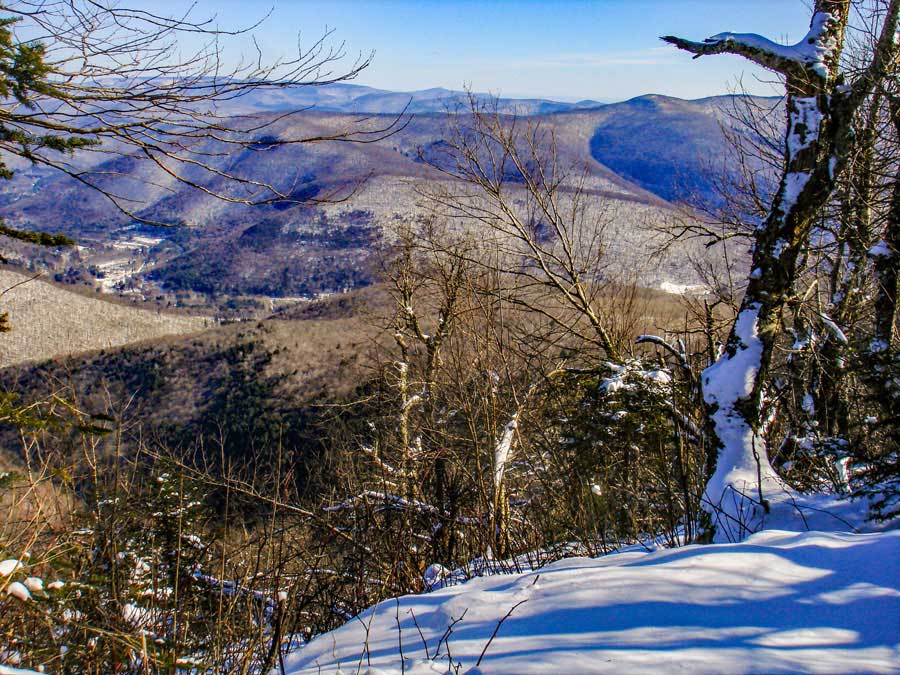
There is a view point 0.19 mile past the side trail to the summit. Many consider this view point the best part of the hike. Once you get done, you can return back to your car on the same route you used to hike up to Balsam Mountain.
|
|
|
S E C T I O N S
|
W E A T H E R
|
O T H E R
|