Catskill Mountaineer

Hike the Little Spring Brook Trail

Little Spring Brook Trail
Little Spring Brook Trail - Taken from Beaver Pond


OVERVIEW

  Trail Name:  Little Spring Brook Trail
  Forest: Delaware Wild Forest
  Parking Area : 2 spaces at end of Pelnor Hollow Road (VERY Difficult - see Notes!)
  Winter Access: Limited Space
   
  Trail Length: 0.75 miles (one-way)
  Trail Type: 80% Double-track trail - 20% Bushwhack
  Hiking Time: less then 1 hours
  Lowest Elevation: 1,903' (A)
  Highest Elevation: 2,099' (A)
  Views : Beaver Pond
  Difficulty: Easy-to-Moderate
   
  USGS Map: USGS Downsville Quad Maps
   
  USGS Map: USGS Lewbeach Quad Maps
   
  DEC Trail Map: DEC Delaware Wild Forest Map (free)
   
  Digital Mapper: Topo     Terrain     Satellite

Maps to Little Spring Brook Trail

Map of the Little Spring Brook Trail in the Delaware Wild Forest


Notes About Hiking the Little Spring Brook Trail

 TRAIL
  The trail is an easy-to-moderate hike for most hikers. The beginning of the trail is an old logging road that is deeply rutted with mossy rocks. Most hikers walk on the sides of the trail to avoid the mossy rocks.

Once you reach the bottom of the Beaver Pond, you will quickly discover that the trail goes right into the pond. Hikers that take that route often move higher up towards the bank. But, most still get wet feet. The best route for hikers is to avoid the pond by hiking higher up on the bank on the west side of the stone wall.

Once you reach the northwestern side of the Beaver Pond, you want to walk around the top corner slightly until you see the Little Spring Brook Trail again. There is a Yellow DEC Trail Marker on a Cherry tree. From there, it is a nice double-track trail that is not rutted and fairly easy to follow.

 PARKING
  LITTLE SPRING BROOK ROAD PARKING AREA - This parking area is actually at the end of the Little Spring Brook Road (public road). You would be parking in the turn-around at the end of the road. It holds about 2 cars. Make sure you get far enough off the turn-around so that cars and trucks can turn around. The Little Spring Brook Trail is rough and not travelled very often. It is overgrown in several areas. Once you get above the beaver pond, the trail is an old road in good shape. The Little Spring Brook is 3/4 of a mile long.

 OTHER INFORMATION
  There is limited cell phone service in some parts of the region (as of 2023).


DIRECTIONS to the Little Spring Brook Roadside Parking from Exit 19 (Kingston)

 
  • Little Spring Brook Parking Area - WGS84 (DEC): 42.026967, -74.877933 - Elevation is approximately 1,903'
  •  
  • Little Spring Brook Parking Area - Deg/Min/Sec: N42 01 37, W74 52 40 - Elevation is approximately 1,903'
  •  
  • Little Spring Brook Parking Area - GPS: N 42 01.618, W 74 52.676 - Elevation is approximately 1,903'
  •  
  • Little Spring Brook Parking Area - UTM: 18N 510105 4652778 - Elevation is approximately 1,903'

  •  
     
  • Get off New York State Thruway at Exit 19 (Kingston).
  •  
  • Take a RIGHT out of the NYS Thruway onto Route 28 West.
  •  
  • Go approximately 46.4 miles on Rt 28 West
  •  
  • Take a LEFT onto Rt 30
  •  
  • Go approximately 19.9 miles on Rt 30 around the Pepecton Reservoir
  •  
  • Take a LEFT onto Rt 206 (Cat Hollow Road)
  •  
  • Go approximately 4.9 on Rt 206
  •  
  • Take a LEFT onto Little Spring Brook Road
  •  
  • Go approximately 1.2 miles on Little Spring Brook Road - Until you reach the end (turnaround)
  •  
  • You can park off the side of the turnaround. Do not block the driveway in the turnaround.
  •  
  • Make sure that you park so that cars and trucks can turn around.
  •  


    Mileage Chart for Little Spring Brook Trail

      Mileage Mile Point Altitude Notes
      0.00 0.00 1,903' Southern Little Spring Brook Trailhead
      0.55 0.55 2,014' Split-Rock Lookout
      0.20 0.75 2,099' Northern Little Spring Brook Trailhead/td>

    Hiking the Little Spring Brook Trail

    Southern Trailhead for the  Little Spring Brook Trail
    Please NOTE: We show this hike starting from the Southern Trailhead from the Little Spring Brook Road. M

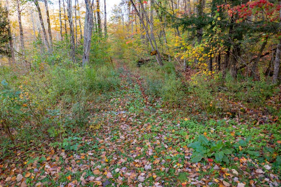
    After hiking up the Little Spring Brook Trail for 3/4 of a mile, you will come to this Trail Junction. RIGHT is the Trailhead for the Pelnor Hollow Trail. Straight is the Trailhead for the Campbell Mountain Trail, which will take you west.
    beginning of the southern trailhead for the Little Spring Brook Trail
    The beginning of the Little Spring Brook Trail starts on this driveway, which used to be part of the Little Spring Brook Road. Please stay on the road and be respectful to the landowners house next to the trail
    Southern Trailhead for the Little Spring Brook Trail.
    This the actual Southern Trailhead for the Little Spring Brook Trail. There is NO DEC registration box at this trailhead. This trail gets very little use, so expect the trail to be overgrown. Just continue to follow the old rutted road.

    Ignore the Trail sign at this trailhead. It is wrong. It belongs at the top of the trail.
    the Little Spring Brook Trail also doubles as a DEC nature trail
    This trail is also designated as an official DEC "Nature Trail". You will see these trail markers for the entire length of the trail. About 3/4 of the way up the trail, you will then see regular yellow DEC Trail Markers in conjunction with the Nature Trail Markers.
    approaching the beaver pond on the Little Spring Brook Trail
    About 1/2 way up the trail, the Little Spring Brook Trail will turn to the right. About 100 feet along the road, the trail slips off the right side of the road and goes into the swamp. After the beavers built a dam, much of the trail is now flooded. You can still follow the old trail, but expect to get wet feet.

    We recommend that you continue staight after 100 feet into the forest and follow the left side of the rock wall. You will need to bushwhack in the forest until you get past the beaver pond. You should be able to see the beaver pond as bushwhack through the forest.
    Beaver Pond on the Little Spring Brook Trail
    Off to the right you will see the pond that has developed after the beavers dammed it up.

    When you get to the northwest side of the beaver pond, follow the contour of the pond. After a short distance you will see the Little Spring Brook Road continue north.
    the Little Spring Brook Trail continues north after reaching the northwestern side of the beaver pond
    As you work around the northwestern side of the pond, you should see the Little Spring Brook Road appear again. Look for the Yellow DEC Trail Marker on the Cherry Tree. Follow the trail you see in the picture.
    the Northern Trailhead for the Little Spring Brook Trail
    About 2/10 of a mile past the Beaver Pond, you will reach the Northern Trailhead of the Little Spring Brook Trail.

    If you continue straight, it will take you down the Campbell Mountain Trail (Blue Trail Markers). This is the Eastern Trailhead for the Campbell Mountain Trail.

    If you turn RIGHT, you will go down the Pelnor Hollow Trail. It also has Blue Trail Markers. This is the Northern Trailhead for the Pelnor Hollow Trail.
    incorrect DEC sign at the northern trailhead of the Little Spring Brook Trail
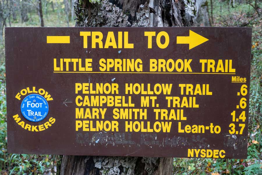
    This DEC Trail sign is partially wrong. It states that the Pelnor Hollow Trail is 6/10 of a mile to the east. This is actually the Trailhead for the Pelnor Hollow Trail.

    The DEC trail sign also states that the Campbell Mountain Trail is 6/10 of a mile to the east. This actually the Trailhead for the Campbell Mountain Trail. The Campbell Mountain Trail actually goes WEST, NOT east.

    The rest of the sign is relatively correctly.

    Links and References:


    DEC Information on the Delaware Wild Forest


    USGS Topo Map of the Downsville Quad


    NY DEC map of the Delaware Wild Forest (free)

    USGS Topo Map of the Lewbeach Quad


      S E C T I O N S


      W E A T H E R


      O T H E R

    Copyright 2001-2024 www.catskillmountaineer.com ALL RIGHTS RESERVED