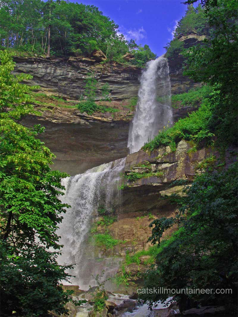
Kaaterskill Falls |
 |
|
| |
| |
|
OVERVIEW |
| | Type of Trail: | 100% DEC Trails |
| | Distance: | 0.60 miles - From Laurel House Road to the Viewing Platform and back |
| | Distance: | 1.74 miles - From Laurel House Road to the Viewing Platform, Bottom of Falls and back |
| | Distance: | 3.12 miles - From Laurel House Road to Viewing Platform, Bottom of Falls, Bastion Falls and back |
| | Elevation Loss/Gain: | 98' loss & gain from Laurel House Road Parking Area to the Viewing Platform and back |
| | Elevation Loss/Gain: | 241' loss & gain from Laurel House Road Parking Area to the Middle of Kaaterskill falls and back |
| | Elevation Loss/Gain: | 577' loss & gain from Laurel House Road Parking Area to Bastion Falls and back |
| | Time: | 1-3 hours round trip (hiking time) |
| | Best Time to Hike: | Any time of the day. Spring, Summer, or Fall (Winter is very icy) |
| | Difficulty: | Very easy to the Viewing Platform - moderate climb to the bottom of Kaaterskill Falls & Bastion Falls. |
| | Highest Elevation: | 2,081' |
|
| | DEC Trail Map: | DEC Map of of the region (free) |
|
| | Digital Mapper: |
Topo
Terrain
Satellite |
|
| | Access Methods: | Foot. |
| | Other Things to do: | Hike the Kaaterskill Rail Trail (3.16 miles round trip) |
| | Other Things to do: | Go swimming at one of the beaches inside North-South Lake Camgrounds. Get a Day-Use Pass at the Entrance Booths to North-South Lake Campgrounds. |
|
|
Maps |
 |
|
 |
|
|
| | DIRECTIONS TO TRAIL HEAD from Exit 21 (Catskill) |
| | NOTE: We do NOT recommend swimming in the middle pool of Kaaterskill Falls. If you would like to swim, get a Day-Use Pass at the Entrance Booths to North-South Lake Campgrounds. There are two beaches located inside the campgrounds that are quite nice. You can also park at the South Lake Parking Area and hike to Kaaterskill Falls.
|
| | Laurel House Road Parking Lot WGS84 (DEC): 42.19575, -74.063433 - Elevation is approximately 2,081 feet |
| | Laurel House Road Parking Lot Deg/Min/Sec: N42 11 44, W74 03 48 - Elevation is approximately 2,081 feet |
| | Laurel House Road Parking Lot GPS: N 42 11.745, W 74 03.806 - Elevation is approximately 2,081 feet |
| | Laurel House Road Parking Lot UTM: 18N 577326 4671935 - Elevation is approximately 2,081 feet |
| | Google Maps: Laurel House Parking Area (Haines Falls, NY) |
| |  : Enter "42.19575,-74.063433" in the Maps Search Box : Enter "42.19575,-74.063433" in the Maps Search Box |
| |
|
| | Scutt Road Parking Lot WGS84 (DEC): 42.200817 -74.058417 - Elevation is approximately 2,240 feet |
| | Scutt Road Parking Lot Deg/Min/Sec: N42 12 02 W74 03 30 - Elevation is approximately 2,240 feet |
| | Scutt Road Parking Lot GPS: N 42 12.049 W 74 03.505 - Elevation is approximately 2,240 feet |
| | Scutt Road Parking Lot UTM: 18N 577734 4672502 - Elevation is approximately 2,240 feet |
| | Google Maps: Scutt Road Parking Area (Haines Falls, NY) |
| | : Enter "42.200817,-74.058417" in the Maps Search Box |
| |
|
| | South Lake Parking Lot WGS84 (DEC): 42.196467, -74.0511 - Elevation is approximately 2,128 feet |
| | South Lake Parking Lot Deg/Min/Sec: N42 11 47, W74 03 03 - Elevation is approximately 2,128 feet |
| | South Lake Parking Lot GPS: N 42 11.788, W 74 03.066 - Elevation is approximately 2,128 feet |
| | South Lake Parking Lot UTM: 18N 578344, 4672026 - Elevation is approximately 2,128 feet |
| | South Lake Parking Area (Haines Falls, NY) (Google Maps) |
| | : Enter "42.196467,-74.0511" in the Maps Search Box |
| |
|
| | Take New York State Thruway to Exit 21 (Catskill). |
| | Take a left out of the NYS Thruway entrance road. |
| | Go approximately 1/4 mile |
| | Take a right onto Route 23 West |
| | Go approximately 6.6 miles to Cairo, NY |
| | Take a LEFT onto Rt 32. McDonalds Rest. on corner. |
| | Go approximately 7.7 miles on Rt 32 |
| | Take a RIGHT onto Rt 23A |
| | Go approximately 7.4 miles to the intersection of Rt 23a and North Lake Road. |
| | Take a RIGHT onto North Lake Road (DEC sign on corner of road). |
| | Go approximately 1.7 miles to Laurel House Road. |
| | Take a RIGHT onto Laurel House Road |
| | Go approximately 0.4 miles to Laurel House Road Parking Area. |
| | Do NOT park on the side of the road. Your car will be TOWED if you do. |
| | NOTE: if the parking area on Laurel House Road is full, then return back to North Lake Road.
NOTE: Take right onto North Lake Road - Go 0.4 miles.
NOTE: Take a RIGHT onto Scutt Road. Parking is near the top of the road. |
| | Do NOT park on the side of the road. Your car will be TOWED if you do. |
| | |
| | |
| | DIRECTIONS TO TRAIL HEAD from Exit 20 (Saugerties) |
| | Laurel House Road Parking Lot WGS84 (DEC): 42.19575, -74.063433 - Elevation is approximately 2,081 feet |
| | Laurel House Road Parking Lot Deg/Min/Sec: N42 11 44, W74 03 48 - Elevation is approximately 2,081 feet |
| | Laurel House Road Parking Lot GPS: N 42 11.745, W 74 03.806 - Elevation is approximately 2,081 feet |
| | Laurel House Road Parking Lot UTM: 18N 577326 4671935 - Elevation is approximately 2,081 feet |
| | Google Maps: Laurel House Parking Area (Haines Falls, NY) |
| | : Enter "42.19575,-74.063433" in the Maps Search Box |
| |
|
| | Scutt Road Parking Lot WGS84 (DEC): 42.200817 -74.058417 - Elevation is approximately 2,240 feet |
| | Scutt Road Parking Lot Deg/Min/Sec: N42 12 02 W74 03 30 - Elevation is approximately 2,240 feet |
| | Scutt Road Parking Lot GPS: N 42 12.049 W 74 03.505 - Elevation is approximately 2,240 feet |
| | Scutt Road Parking Lot UTM: 18N 577734 4672502 - Elevation is approximately 2,240 feet |
| | Google Maps: Scutt Road Parking Area (Haines Falls, NY) |
| | : Enter "42.200817,-74.058417" in the Maps Search Box |
| |
|
| | South Lake Parking Lot WGS84 (DEC): 42.196467, -74.0511 - Elevation is approximately 2,128 feet |
| | South Lake Parking Lot Deg/Min/Sec: N42 11 47, W74 03 03 - Elevation is approximately 2,128 feet |
| | South Lake Parking Lot GPS: N 42 11.788, W 74 03.066 - Elevation is approximately 2,128 feet |
| | South Lake Parking Lot UTM: 18N 578344, 4672026 - Elevation is approximately 2,128 feet |
| | South Lake Parking Area (Haines Falls, NY) (Google Maps) |
| | : Enter "42.196467,-74.0511" in the Maps Search Box |
| |
|
| | Take New York State Thruway to Exit 20 (Saugerties). |
| | Take a left out of the NYS Thruway entrance road - Move to RIGHT lane. |
| | Go approximately 0.20 miles |
| | Take a right onto Route 32 |
| | Go approximately 5.9 miles to a Y intersection |
| | Take a LEFT (straight) onto Rt 32A (Gas Station on left side of road). |
| | Go approximately 1.8 miles on Rt 32A |
| | Take a LEFT onto Rt 23A |
| | Go approximately 5.2 miles to the intersection of Rt 23a and North Lake Road. |
| | Climb up the windy mountain road (Rt 23A). When you reach the top, you will then be in Haines Falls. |
| | Take a RIGHT onto North Lake Road (DEC sign on corner of road). |
| | Go approximately 1.7 miles to Laurel House Road. |
| | Take a RIGHT onto Laurel House Road |
| | Go approximately 0.4 miles to Laurel House Road Parking Area. |
| | Do NOT park on the side of the road. Your car will be TOWED if you do. |
| | NOTE: if the parking area on Laurel House Road is full, then return back to North Lake Road.
NOTE: Take right onto North Lake Road - Go 0.4 miles.
NOTE: Take a RIGHT onto Scutt Road. Parking is near the top of the road. |
| | Do NOT park on the side of the road. Your car will be TOWED if you do. |
|
|
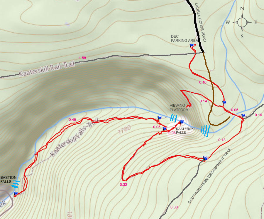
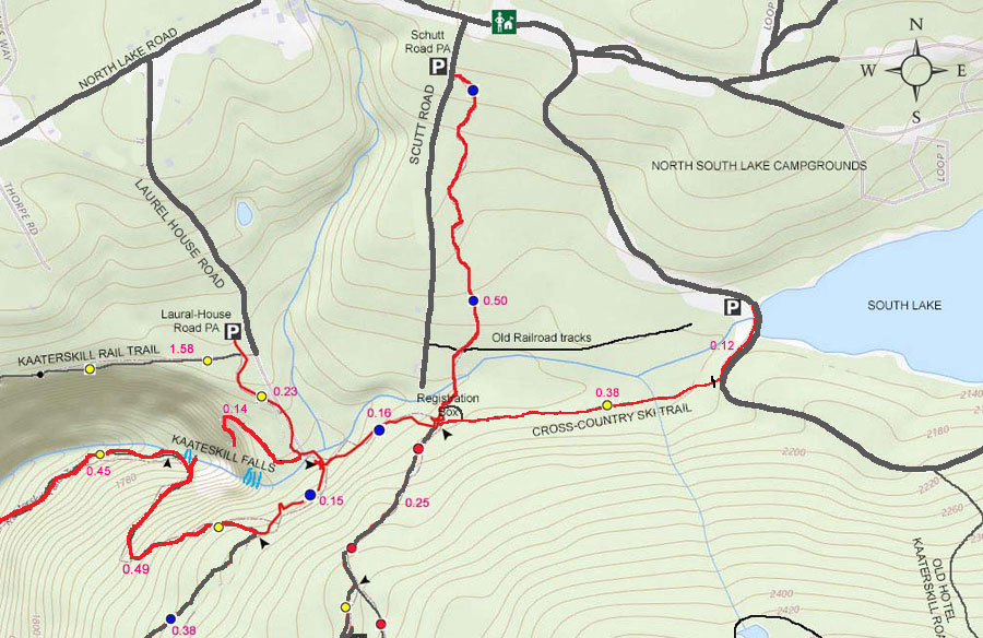
MILEAGE CHART |
| | Mile Point | Altitude | Notes |
| | 0.00 | 2,081 | DEC Parking Area - At the end of Laurel House Road. If full use the DEC Parking Area at the top of Scutt Road. |
| | 0.16 | 2,025' | Trail Junction - Turn RIGHT. |
| | 0.30 | 2,017' | Viewing Platform. |
| | 0.44 | 2,090' | Trail Junction - Go RIGHT and walk over steel bridge. |
| | 0.49 | 2,056' | At the Trail Junction - Take a RIGHT onto the Escarpment Trail towards Layman's Monument |
| | 0.62 | 2,111' | At Trail Junction - Take RIGHT down to the bottom of Kaaterskill Falls. |
| | 0.94 | 1,806' | At Trail Junction - Take RIGHT if you want to go to the middle pool of Kaaterskill Falls. |
| | 1.00 | 1,796' | Middle Pool of Kaaterskill Falls. |
| | 1.06 | 1,806' | Return back to Trail Junction - Take RIGHT to get to the bottom of Kaaterskill Falls. |
| | 1.11 | 1,722' | Bottom of Stairs (not actual bottom of Kaaterskill Falls |
| | 1.56 | 1,484' | Trail Head on Rt 23a - Bastion Falls |
| | 3.12 | 2,081' | DEC Parking Area - Laurel House Road |
|
|
Hike to the Viewing Platform to Kaaterskill Falls |
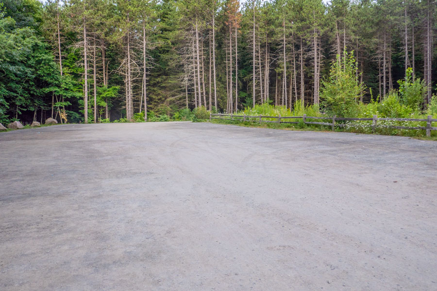 |
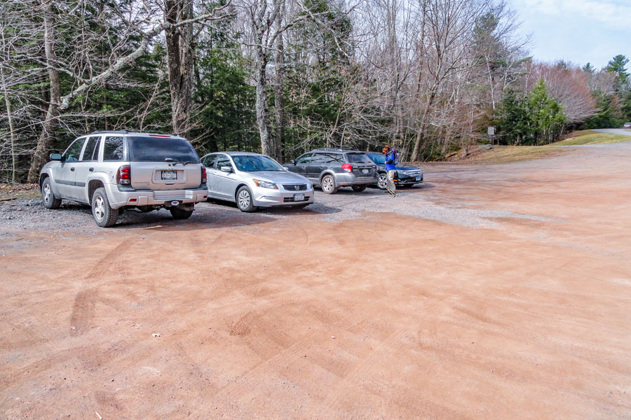
This is the LAUREL HOUSE ROAD DEC PARKING AREA.
If this Parking Area is full, do NOT park on the side of the road. The Town of Hunter WILL tow your car! Instead, drive back to North Lake Road. Take a RIGHT onto North Lake Road. Drive about 1/4 mile. Take a RIGHT onto Scutt Road. There is another DEC Parking Area near the top of Scutt Road.
The Trail Head starts at the bottom middle of the Parking Area. Skip over the next THREE section to start your hike.
Do not leave trash in the Parking Area or outhouses!
|
|
 |
This is the SCUTT ROAD DEC PARKING AREA.
The picture shows the upper part of the Scutt Road Parking Area. There is also a lower Scutt Parking Area. There is an outhouse located in the lower lot.
Go to lower parking lot (if in upper lot).
Go Across Scutt Road - Trail Head (BLUE Trail Marker)
Go 0.50 miles (1/2 mile) to Registration Box and 4-way intersection.
Take a RIGHT and hike down 0.16 miles.
Take a RIGHT and hike over steel bridge
Take a LEFT at the next Trail Junction
Skip down a FOUR section on this page to continue to the View Platform of Kaaterskill Falls.
Do not leave trash in the Parking Area or outhouses!
|
|
 |
This is the SOUTH LAKE PARKING AREA inside the North-South Lake Campgrounds.
Go into North-South Lake Campgrounds ($ for access to campground (parking, swimming, beach, etc))
After leaving Campground Entrance Booth - Take RIGHT
Park car at dirt parking area by South Lake
Walk over dam with overflow pipe on paved road.
Walk on the paved road 0.12 miles (600 feet).
Look for wooden bar across the path (RIGHT side of road).
That is the Cross-Country Ski Trail.
Walk down the cross country ski trail 0.38 miles
At the 4-way intersection, go STRAIGHT.
Go 0.16 miles (800 feet) down the trail.
Go RIGHT over steel bridge.
Take a LEFT at the next Trail Junction
Skip down a THREE section on this page to continue to the View Platform of Kaaterskill Falls.
Do not leave trash in the Parking Area or outhouses!
|
|
 |
 |
The image on the left is the Trail Head. It is located at the center of the bottom part of the Parking Area. 50' down the path is a Bear-Proof garbage can and the Kiosk.
NOTE: This region has the highest concentration of black bears in New York State! Make SURE you put any garbage in the brown bear-proof garbage cans! If the garbage cans are full, then take the garbage with you. DO NOT LEAVE ANY GARBAGE ON THE GROUND! Or, in the Outhouses, registration boxes, on in the trees. The bear-proof garbage cans are located next to the kiosk. See picture on the left.
On the right, Just around the Kiosk, is the Kaaterskill Rail Trail (1.58 miles one-way). For this hike, you want to continue STRAIGHT. |
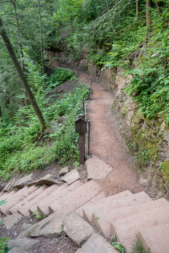
The image on the right is what the trail down to the Kaaterskill Falls Viewing Platform looks like. |
|
 |
 |
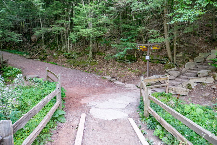
After a short distance of a little less then 2/10 of a mile, you will come to the Trail Junction for the viewing platform for Kaaterskill Falls. You want to go STRAIGHT. |
If you decide to visit Kaaterskill Falls, please review the rules for the Kaaterskill Falls Region. |
|
 |
 |
This is what the trail looks like down to the viewing platform to Kaaterskill Falls |
This is what the trail looks like down to the viewing platform to Kaaterskill Falls |
|
 |
 |
This is what the trail looks like down to the viewing platform to Kaaterskill Falls |
This is what the trail looks like down to the viewing platform to Kaaterskill Falls |
|
 |
Once you go around this corner, you will be on the Viewing Platform for Kaaterskill falls. You can see both the upper and lower falls. |
|
 |
This is the Viewing Platform for Kaaterskill falls. You can see both the upper and lower falls. Off in the distance is Roundtop Mountain. |
|
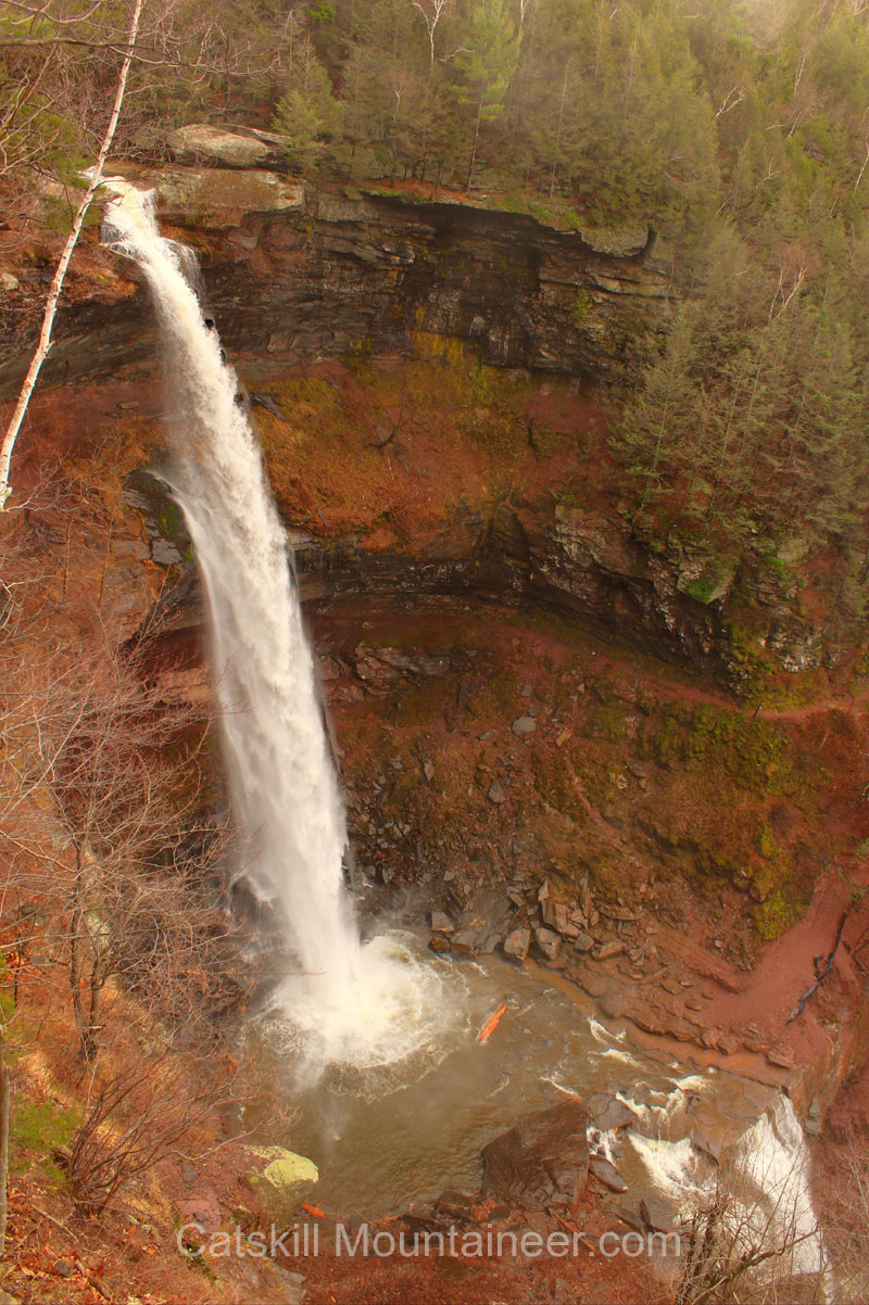 |
Picture taken from the Viewing Platform for Kaaterskill falls. You can see both the upper and lower falls. This photograph was taken in the late Fall season.
|
|
 |
Return back to the Trail Junction. It is 0.16 miles (850 feet) slightly uphill.
If you want to go to the bottom of Kaaterskill Falls, go RIGHT over the steel bridge.
If you are done, and want to return back to the Laurel House Parking Area, go LEFT. The Laurel House Parking Area is 0.14 miles away
If you are done, and want to return back to the Scutt Parking Area, go RIGHT and go over the steel bridge. Then Left parallel to Lake Creek. Then LEFT at the 4-way Intersection. The Scutt Parking Area is 3/4 mile away.
If you are done, and want to return back to the South Lake Parking Area, go RIGHT and go over the steel bridge. Then Left parallel to Lake Creek. Then STRAIGHT at the 4-way Intersection. Then LEFT at the end of the trail. The South Lake Parking Area is 3/4 mile away.
|
|
HIKE to BOTTOM of KAATERSKILL FALLS |
| At the trail junction, you want to go RIGHT.
The trail on the right will take you to the trail that takes you the bottom of Kaaterskill Falls.
The trail on the left will take you to Scutt Road Parking Area and North-South Lake Campgrounds. |
|
 |
About 0.15 miles (800') you will come to a trail junction. You want to to RIGHT and walk down the steps you see in this picture.
SAFETY NOTE #1: The trail to the middle pool and bottom of Kaaterskill Falls will take you down hundreds of steps. If you are not good shape, tired, or not feeling well, you might want to reconsider going down this trail. It is like walking down the stairs of a 30-story building, and then walking back up.
Straight will take you further down the Southern Escarpment Trail.
|
|
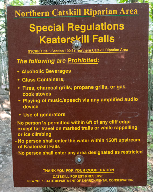 |
SAFETY NOTE #2: 200+ people have been killed at Kaaterskill Falls. And countless people have been injured. These rules are here for a reason!
SAFETY NOTE #3: Do NOT leave any trash on the trail or parking area. This region has a highest population of Black Bears in the region. Once bears find food here, they start demanding food from people. Then we start having bear mauling. Normally, black bears are very docile and will not bother people. Let's keep it that way.
|
|
 |
 |
Walk down the stairs to start your hike down the trail to the bottom of Kaaterskill Falls |
As you can see the beginning of the trail is pretty easy. |
|
 |
 |
As you get further down the trail will become steeper and you will encounter more stair |
Then you will encounter continuous stairs.
SAFETY NOTE #4: TAKE YOUR TIME GOING DOWN THE STAIR! Do not allow others to force you to move faster. The treads to the steps are NOT consistent. Nor, is the rise of the steps. If you stumble, and fall, you will be seriously injured. |
|
 |
When you reach this Trail Junction, the trail going off to the right will take you to the middle pool of Kaaterskill Falls.
SAFETY NOTE #5: If it is icy then it is not safe to enter without microspikes or crampons. If the water flow is at moderate-to-high levels, it is not safe to go to the middle pool. If you are traveling down the trail and water mist is blowing in your face, then it is not safe.
|
|
 |
The photograph shows what the middle pool looks like at low water flow. Some people do swim in the pool when the water flow is low.
SAFETY NOTE #6: It is NOT safe to swim in the pool at moderate to high water flow. People have drown or be washed over the lower falls to their death.
|
|
 |
This photograph shows the water flow when it is at a low level. Note the person under the falls.
SAFETY NOTE #7: Do not go under the waterfall when the water level is at moderate or higher levels. Also do not climb up the bank under the ledge. Numerous people have climbed up there and fell to their death or have been seriously injured.
|
|
 |
This is the top of the lower falls. Remember to keep at least 6 feet away during low water levels.
SAFETY NOTE #8: The rock has been ground smooth by thousands of years to water flowing over the rock. It is slippery. Algae and clay slime is often on the surface, which makes it even more slippery. Algae is present on the rock even when the temperatures fall below freezing. Countless people have fallen off the top or been sweep off the lower falls to their death.
|
|
 |
 |
These are the stairs to the bottom of Kaaterskill Falls. There around 100 steps. Be very careful going down them! |
This is the view at the bottom of the stairs looking up. |
|
|
This is the view of Kaaterskill Falls at Moderate-to-High water flow. The bottom of the falls gives you a real feeling of grandeur.
|
|
HIKE to BASTION FALLS |
 |
 |
The trail to Bastion Falls is fairly rocky. These two pictures are the easier sections of the trail. | <
If the rocks are wet or icy, you should use extra caution. |
|
 |
 |
There are sections with rock steps. |
And, sections with wood and dirt steps. |
|
 |
This is the Trail Head for Bastion falls. There is a DEC Registration box behind the Kiosk.
This Kiosk is directly off Rt 23a on the Horseshoe curve that goes over Lake Creek. You can see Bastion Falls as you drive over the bridge on Rt 23a.
|
|
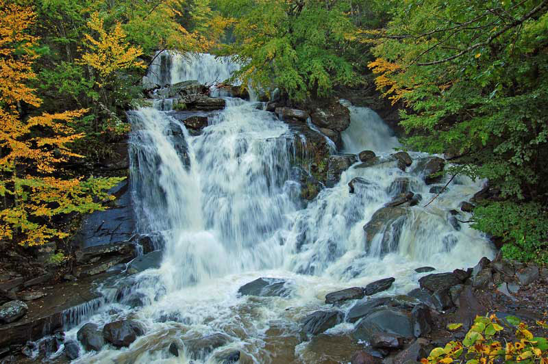 |
This is probably the best photograph taken of Bastion Falls. It was taken by Richard Kugel and is his intellectual property.
|
|
 |
 |
These two photographs are the rock steps just beyond the Trail Head Kiosk on Rt 23a.
There are a series of rock steps. Further up the side of Bastion Falls, the steps become wood & dirt steps. Take your time and be careful walking up or down these steps. |
Continue back up the trail to the top of Kaaterskill Falls. Take your time and take breaks as needed. If you get tired, you should rest. |
|
 |
Once back up at the top of the Kaaterskill Falls Trail, you want to take a LEFT.
Right will take you to the Southern Escarpment and Layman's Monument.
|
|
|
When you come down the stairs on the right side of the photogragh, you should do the following:
If you are parked at Laurel House Road Parking Area you should take a LEFT.
If you are parked at Scutt Road DEC Parking Area take a RIGHT. The 4-way intersection is located 850' up the trail parallel to Lake Creek. Then take a LEFT.
If you are parked at South Lake Parking Area take a RIGHT. The 4-way intersection is located 850' up the trail parallel to Lake Creek. Then continue STRAIGHT. At the end of the trail take a LEFT.
|
|
|
S E C T I O N S
|
W E A T H E R
|
O T H E R
|