|
Overview of this Hike: |
| Distance: 6.23 mile trip from DEC parking lot on Scutt Road. |
| Time: 4 hours round trip (hiking time) |
| Elevation Difference: 555' from the highest point to the lowest point |
| Side Trips: Catskill Mountain House site |
| Best Time to Hike: Morning is best for Bear's Den |
| Difficulty: Easy-to-moderate |
| VO Map No: #15 - #12 - #95 - #12 - #122 - #12 |
| Catskill Highest: 100+ |
| Highest Elevation: 2,655' |
| |
| Digital Mapper:
Topo
Terrain
Satellite |
| |
| Access Methods: Foot and snowshoeing. |
|
Maps, Profile, and GPS files |
 |
|
|
Directions to Trail Head from New York State Thruway (Easist, not the shortest): |
| Take New York State Thruway to Exit 21 (Catskill). |
| Take a left out of the NYS Thruway entrance road. |
| Go approximately 1/4 mile |
| Take a right onto Route 23 West |
| Go approximately 6.6 miles to Cairo, NY |
| Take a LEFT onto Rt 32. McDonalds Rest. on corner. |
| Go approximately 7.7 miles on Rt 32 |
| Take a RIGHT onto Rt 23A |
| Go appoximately 7-8 miles to the intersection of Rt 23a and North-South Lake Road. |
| Climb up the windy mountain road (Rt 23A). When you reach the top, you will then be in Haines Falls. |
| Take a RIGHT onto North Lake Road (DEC sign on corner of road). |
| Follow North Lake Road until you almost reach the DEC booths. |
| Take a RIGHT onto Scutt Road. |
| Take a RIGHT into the DEC parking lot. The parking lot fills up quickly. If the parking lot is full, you can park on the side of the road. Do NOT park down by the two houses. |
| Mile Post | Altitude | Notes |
| 0.00 | 2,290 | DEC Parking lot on Scutt Road. Take of LEFT out of the parking lot, and walk up to North Lake Road. N42 12.029 W74 03.507 |
| 0.08 | 2,315' | Take a LEFT onto North Lake Road (Walk west away from DEC campgrounds) and walk 50'. Across the road is the trail entrance. |
| 0.09 | 2,315' | The trail starts is easy to miss. It is on the north side of the road. |
| 1.37 | 2,481' | Trail Junction. Left will take you to North Point and North Mountain. Right will take you to the next trail junction 200' east of the rock ledge. Go RIGHT down to the bottom of the rock ledge. |
| 1.41 | 2,452' | Trail Junction. Right will take you to Ashley Falls and North Lake campgrounds. Left will take you Bad Man's Cave and Newman's Ledge. Go LEFT. |
| 1.85 | 2,655' | Bad Man's Cave, Trail Junction, and Bog. Left (up steep hill) will take you North Mountain. Straight will take you to Newman's Ledge. Go STRAIGHT. N42 12.839 W74 02.084 |
| 2.42 | 2,500 | Newman's Ledge. N42 12.614 W74 01.846 |
| 2.62 | 2,464 | Trail Junction. Left will take you to Bear's Cave (DEC has it mismarked as Sunset). Take LEFT. |
| 2.82 | 2,461 | Bear's Den. N42 12.321 W74 01.858 . Reverse back to Escarpment trail after enjoying the great views of North and South Lake. |
| 3.01 | 2,464' | Trail Junction. Take LEFT and walk under the Bear's Den |
| 3.30 | 2,417' | Sunset Rock. Not marked. |
| 3.48 | 2,286 | Prospect Rock (DEC has it mismarked as Artist Rock). N42 12.127 W74 01.770 |
| 3.89 | 2,175 | Leave Trail and walk down to North Lake Beach. Look for trail LEFT of the beach. |
| 4.06 | 2,155 | Start of Lake trail. Gate across the trail. Trail runs parallel with North Lake. |
| 4.37 | 2,162' | Alligator Rock. N42 11.852 W74 02.409 |
| 4.51 | 2,188 | Leave Trail and continue on asphalt road (by picnic area). Dirt road to the left will take you to the old Catskill Mountain House. Go RIGHT if you do not wish to visit the old Catskill Mountain House. |
| 4.70 | 2,176 | Mountain Bike Trail on left side of the road. Just past the South Lake beach. Continue down the road. |
| 5.11 | 2,210 | Old Kaaterskill Hotel Road on left side of the road. Continue down the road. |
| 5.26 | 2,172 | Ski Trail on left side of road. Take LEFT down ski trail. |
| 5.56 | 2,150 | Take a LEFT onto the old Scribner Mill Road (unmarked wagon trail) |
| 5.60 | 2,128 | Scribner Mill House |
| 5.68 | 2,125 | Take a Sharp RIGHT back onto the trail. Careful that you don't miss the turn. |
| 5.79 | 2,141 | Take a LEFT onto the old Rail Road tracks. |
| 5.84 | 2,141 | Take a RIGHT onto Scutt Road from the old rail road tracks. |
| 6.23 | 2,292 | Return back to the parking lot. |
|
Hike to Newman's Ledge, Bear's Den, Sunset Rock, Prospect Rock, and Artist Rock |
 |
You can park in the DEC parking lot. The parking lot does fill up, so you can also park on the side of the road of Scutt Road.
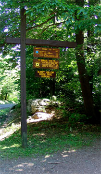
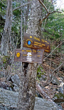
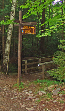
From the parking lot there are threes possible directions you can go. (1) You can walk back UP Scutt Road to North Lake Road; (2) You can walk across Scutt Road and take the Blue Trail. (3) You can walk directly down Scutt Road and pick up the Rail Road Track trail and meet up the Blue Trail. You want to walk UP the Road to North Lake Road (county route 18). The picture on the LEFT is the sign by the DEC parking lot.
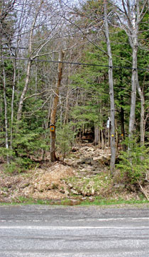
Once you get to the intersection of Scutt Road and North Lake Road (Cty Rt 18), take a LEFT and start walking back down North Lake Road (away from the DEC campground). After walking about 50 feet you will see another DEC sign. Across the road from the sign is the entrance of the trail.
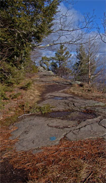
The picture on the RIGHT shows the entrance of the trail. Very few people actually see the entrance of the trail, when they drive by. At Mile Post 0.09, you will enter the entrance of the hiking trail. |
 |
|
|
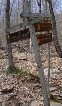 |
At mile post 1.37, you will encounter the DEC sign on the LEFT for the next Trail Junction. At this trail junction, you want to take a RIGHT and climb down the ledge.
Even when it is dry, the section below the ledge will still have water. After large rain storms, the area below the ledge is very wet, and may have a significant amount of water flowing below the ledge.
At mile post 1.41 you will encounter a second DEC sign. This is the other Trail Junction. This sign is about 200 feet from the first trail junction. At this SECOND trail junction, you want to go LEFT up the hill. The picture on the RIGHT shows the DEC sign. The trail up the hill often has ice flows in the winter and is very difficult to climb without cramp-ons. |
 |
|
|
 |
At mile post 1.85, you will encounter the DEC sign on the LEFT for the next Trail Junction. At this trail junction, you want to continue going STRAIGHT. On your left is Bad Man's Cave. On your right is a 3,700 year old bog.
The picture on the right is Bad Man's cave. The cave got it's name from outlaws who would commit crimes in the valley, and then hide out here.
. |
 |
|
|
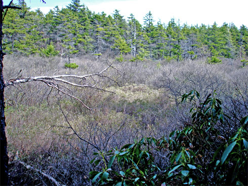 |
This bog is approximately 3,430 years old (calculated by radiocarbon dating) and is 23 inches deep. It is called Bog #308. It is the 7th oldest bog in the Catskill Mountains. Bogs are typically very acidic with a pH of 3.5 to 4.0. This preserves plant life for thousands of years. This information is important for scientific research. This information comes from Michael Kudish's book, "The Catskill Forest - A History" (page 15).
. |
|
|
 |
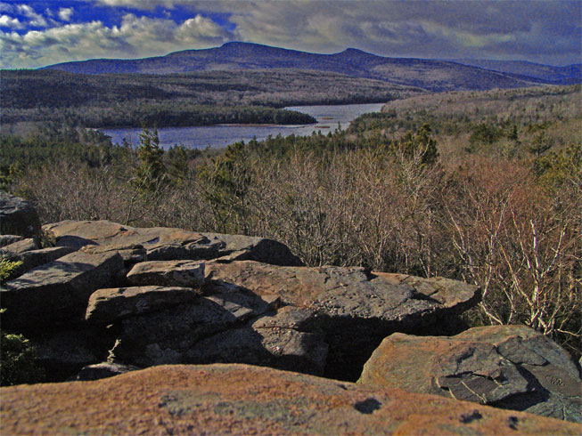
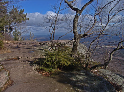
At mile post 2.42 you will encounter Newman's Ledge. Newman's ledge over looks the Hudson Valley. You can see the Hudson River in the background. On your left is Rip's Ridge. Just below the ledge is Rip's Rock. At the bottom of the ledge is Rip Van Winkle's House and Rip's Boulder. The vertical drop below Newman's Ledge is estimated to be around 500 feet, so don't fall off.
. |
|
|
 |
After walking down a steep hill and at mile post 2.62 you will encounter another trail junction. This is a side trip, but this very short trip has one of the best views in the Catskill Mountains. The DEC has mismarked it as "Sunset Rock". It is actually called "Bear's Den".
. |
|
|
 |
After a very short and easy walk, you will encounter Bear's Den at mile post 2.82. After you are done enjoying the view, just reverse your course back to the Escarpment Trail. This is a side trip, but this very short trip has one of the best views in the Catskill Mountains. The DEC has mismarked it as "Sunset Rock". The correct name is, "Bear's Den". GPS: N42 12.321 W74 01.858. 100 Years ago, there was a wooden ladder on the south side of Bear's Den. It was called Jacob's Ladder. There are some people who believe that some of the steep areas are called Jacob's Ladder, but this is not the case.
. |
|
|
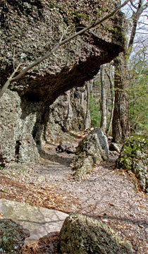 |
As you return back to the Escarpment trail, you will then walk under Bear's Den. While walking under Bear's Den, you will walk under an overhang of conglomerate rock. This is what is pictured on the Left side of the screen.
The picture on the right is Sunset Rock. Years ago, the view was much better because the trees were cleared out for an expanded view. It is located at mile post 3.30.
. |
 |
|
|
 |
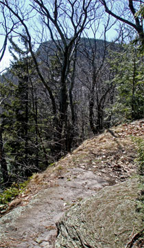
At mile post 3.48 you will encounter a long ledge. The DEC sign states that it is Artist Rock. This is incorrect. It is actually Prospect Rock. This is a very long ledge. GPS: N42 12.127 W74 01.770
. |
|
|
 |
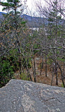
The picture on the LEFT shows Prospect Ledge from the southern most position. This shows the long length of the ledge.
The picture on the RIGHT is Artist Rock. Many years ago, you could see Catskill Mountain House from this location. But, the trees have grown up, and are blocking the view. Many famous painting were done of Catskill Mountain House during this period from multiple locations. But, it is this location that was used by the Catskill Mountain House on their letterhead logo.
. |
 |
|
|
 |
When you come to the campground area, cut across the lawn and find the beach. On the left of the beach is the old hotel road. There is a gate closing the road. Walk down the road. The road runs along the lake coast line. When you come to the inlet/outlet to North and south lake, continue on the trail in the other direction.
At mile post 4.37, you will come upon Alligator Rock. This rock was very popular when the Catskill Mountain House existed in the 1800's and early 1900's.
At mile post 4.51, you will come to North Lake Road (near the picnic area). Follow the road westward.
At mile post 4.70, you will pass the mountain bike trail on the left (just after the beach)
At mile post 5.11, you will pass the old Kaaterskill Hotel Road (rock in the middle of the path) |
|
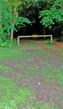 |
At mile post 5.26 (elevation 2,172') you will come to a trail junction on the left side of the road. You can see it on the picture on the left. This is the Cross-Country Ski Trail. You want to leave South Lake Road for the Ski Trail. Take a LEFT, and walk around the barrier.
At mile post 5.56, you will encounter an old wagon trail on the RIGHT (It is just before the major intersection trail junction). When you walk down the hill of the wagon trail you will come upon the old Scribner Saw Mill at mile post 5.60 (200 feet).
NOTICE: If you miss the old wagon trail, you can take a RIGHT at the major trail intersection. Then take a RIGHT at the Y intersection. You want to go RIGHT over the wooden bridge. Pictured on the right is the trail junction if you miss the wagaon trail
|  |
|
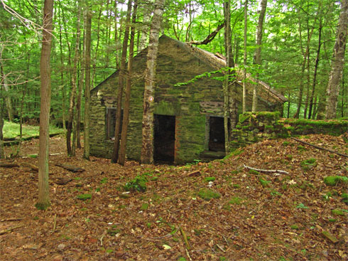 |
At mile post 5.60, you will encounter the Scribner Saw Mill. The standing structure is the old office. The saw mill was actually on the left of the office. The only part of the saw mill left is the foundation.
|
|
 |
At mile post 5.68, you will encounter another Trail Junction. You want to take a sharp RIGHT (almost a 180 degree turn).
At Mile post 5.79 (elevation 2,141') you will encounter another Trail Junction. This trail junction is for the old rail road tracks Going Left will take you to Scutt Road (about 200' away). Going Straight will take you back to the Scutt Road Parking Lot. You can go either direction. Going Left is 0.33 miles back to your car, and is an easier hike. Going Straight is 0.44 miles back to your car, and more difficult. If you go left, you want to go Right after reaching the Road 200' later.
|
|
|
S E C T I O N S
|
W E A T H E R
|
O T H E R
|
|