|
Information about Hillyer Falls: |
| Name: Hillyer Falls |
| County: Greene |
| Region: Kaaterskill Clove |
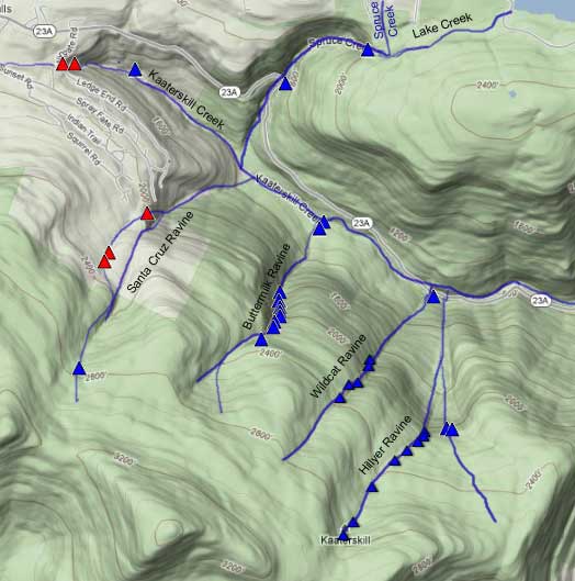
| Location: Hillyer Ravine |
| Order within east side of the ravine: 1st of 2 drops (1=highest elevation) |
| Order within waterfall: 1 of 1 (1=highest elevation) |
| Total Height: ~100' (Yet to be GPS'ed)) |
| Top Elevation: 2,140 |
| Bottom Elevation: ? |
| Type of Waterfall: plunge+cascade+plunge |
| Number of Drops: 2 |
| GPS location: N 42 10.119, W 74 03.284(top of waterfall) |
| WGS84 location: 42.16865, -74.05473 (top of waterfall) |
| UTM location: 18N 578078 4668934 (top of waterfall) |
| Named: 1800's |
| Previous or Alternate Names: none known |
| Description: Hillyer Falls does not have a big volume of water flowing over the top of the Falls. In the summer it can almost dry up. In the Spring it adds a nice sound at Poet's Ledge, which is directly above the Falls. |
| Hiking Distance: ~7.5 miles (round trip) from Palenville. |
| Hiking Distance from Trail: Less then 1/4 mile from Poet's Ledge |
| Trail Information: Waterfalls & Poet's Ledge hike |
| Time: Average 5 hours round trip |
| Elevation Gain: 1,600 from Rt 23a. |
| Difficulty: Easy - You can access just before you reach Poet's Ledge. Leave the trail in the conifer forest and head west. |
| Final access to top of waterfalls: Hike |
| Final access to bottom of waterfalls: Hike up from Kaaterskill Creek near Fawn's Leap. You may be able to access it from the west side of Viola Falls. Access to the bottom is very difficult. You can access the middle section (where the pictures were taken) by going west of Shadow Falls and climbing down the rim. |
| Map No: VO: #19 - TC: Map #141 - NG: #19 - USGS: Kaaterskill Quad |
| Digital Mapper: Topo
Terrain
Satellite |
| Known Access Safety: Mossy and slippery rocks |
| Unattractions:Long hike to get there |
| Common Animals: bears! |
| Risky Animals:
Bears (high) |
| Access Methods: Hike |
|
Maps, Profile, and GPS files |
 |
|
|
Directions to Trail Head from New York State Thruway (Easist, not the shortest): |
| Take New York State Thruway to Exit 21 (Catskill). |
| Take a left out of the NYS Thruway entrance road. |
| Go approximately 1/4 mile |
| Take a right onto Route 23 West |
| Go approximately 6.6 miles to Cairo, NY |
| Take a LEFT onto Rt 32. McDonalds Rest. on corner. |
| Go approximately 7.7 miles on Rt 32 |
| Take a RIGHT onto Rt 23A |
| Go approximately 3.0 miles on Rt 23A . |
| When you come out of Palenville, you can park in 3 different areas. (1) Park just before bridge (west bound lane); (2) Park 1/4 mile past bridge; (3) Park 4/10 mile before bridge in DEC parking lot. |
| You cannot park at the trail head! |
| Do NOT park by the red building next to the bridge. |
| Do NOT park on Malden Ave or in someones driveway on Malden Ave. |
| Do NOT drive up the dirt entrance road to the trail head - this is PRIVATE property - AND there is NO place to park or turn around once you get to the trail head. |
|
Comments about this Hike |
| Hillyer Falls is located close to the DEC Trail to Poet's Ledge. There is another two waterfalls in the eastern part of Hillyer Ravine. The two waterfalls are twins. They are both very close to each other. Some people will also visit Middle Viola and Viola Falls during this hike. After looking Hillyer and Shadow Falls, continue to bushwhack along the rim until you Reach Middle Viola Falls. You can then hike up the stream to reach Viola Falls. This way you will see four waterfalls. You could then continue to see Wildcat, Buttermilk, and Paradox Falls. |
| Mile Point | Altitude | Notes |
| 0.00 | 680 | Parking - From Route 23A turn onto Malden Ave - Walk past double guard rails (watch out for poison ivy on left side of road). |
| 0.62 | 680 | Walk up wide dirt driveway about 250 ( look for green Long Path trail marker on tree - hard to see from Malden Ave) - Turn right and walk up narrow dirt driveway past metal gate (If gate is closed, walk around gate). |
| 1.01 | | Road branch - Go straight |
| 1.27 | | Road branch - Go Right |
| 1.33 | 1,255 | Road Branch - Go Right - leave dirt road and continue onto the foot path |
| 1.40 | | Leave private land onto public land |
| 2.13 | 1,955 | Level off for a while |
| 2.31 | 2,067 | Giant steps |
| 2.34 | 2,102 | Ledge #1 (views) |
| 2.44 | 2,264 | Rock-in-the-Path |
| 2.52 | 2,325 | Reach top of moderate ascent - Levels off after this for several miles. Total ascent of 1,661. |
| 2.57 | 2,317 | Start of Boreal Forest (Watch for black bears at this point) |
| 2.63 | 2,341 | Trail Branch - go right to Poets Ledge (0.44 miles) - Yellow trail markers |
| 2.98 | 2,187 | Mossy Notch |
| 3.07 | 2,145 | POETS LEDGE - Outstanding View! - Enjoy. Be careful of the opening between the rocks on the ledge. It is a 30 fall. There are blueberry bushes around the ledge, which bears can be very possessive of (end of June - early July). |
| 3.25 | 2,140 | Just before you reach Poet's Ledge, take a LEFT and bushwhack along the rim until you reach Hillyer Falls. Hillyer Falls is surrounded with conifer trees. When the trees get thick, you are almost there. |
| 6.50 | 680 | Return back to Rt 23a. |
|


