Indian Head Mountain on the Devil's Path |
 |
| |
| |
|
OVERVIEW |
| | Distance: | 6.16 miles round trip from DEC parking lot from Prediger Road and back to the parking lot. |
| | Time: | Average 4.75 hours round trip |
| | Elevation Gain: | 1,515 feet from parking lot to the summit of Indian Head Mountain. |
| | Best Time to Hike: | Morning. |
| | Difficulty: | Very Difficult |
| | Catskill Highest: | #30 |
| | Peak Elevation: | 3,573' |
| | | |
| | | USGS Official Names: | Indian Head Mountain (ID: 953655) |
| | USGS Summit-Elevation: | 3,553' (USGS) |
| | USGS Indian Head-Summit-WGS84: | 42.116201, -74.114585 (DEC-WGS84) |
| | USGS Indian Head-Summit-GPS: | N 42 06.972, W 74 06.875 (GPS) |
| | USGS Indian Head-Summit-UTM: | 18N 573195, 4663057 (UTM) |
| | USGS Indian Head-Summit-Deg, Min, Sec: | N42 06 58, W74 06 52 (Degree, Min, Sec) |
| | |
| | | USGS Official Map: | Woodstock Topographical Map (free) |
| | |
| | | Acme Digital Mapper: |
Topo
Terrain
Satellite |
| | |
| | | Access Methods: | Foot and snowshoe |
|
|
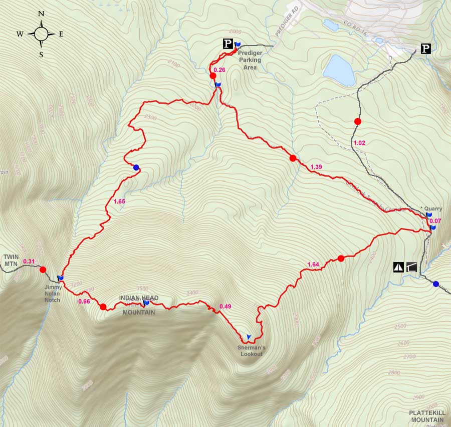
Maps |
 |
|
|
| | DIRECTIONS TO TRAIL HEAD |
| | Prediger Road Parking WGS84 (DEC): 42.134033, -74.10435 - Elevation is approximately 2,000 feet |
| | Prediger Road Parking Deg/Min/Sec: N42 08 02, W74 06 15 - Elevation is approximately 2,000 feet |
| | Prediger Road Parking GPS: N 42 08.042, W 74 06.261 - Elevation is approximately 2,000 feet |
| | Prediger Road Parking UTM: 18N 574020, 4665046 - Elevation is approximately 2,000 feet |
| | Take New York State Thruway to Exit 21 (Catskill). |
| | Take a left out of the NYS Thruway entrance road. |
| | Go approximately 3/4 mile |
| | Take a right onto Route 23 West |
| | Go approximately 6.6 miles to Cairo, NY |
| | Take a LEFT onto Rt 32. McDonalds Rest. on corner. |
| | Go approximately 7.7 miles on Rt 32 |
| | Take a RIGHT onto Rt 23A |
| | Go appoximately 9 miles to Tannersville NY. |
| | At the only RED LIGHT, take a LEFT onto Rt 16 (platteclove road) |
| | Go approximately 5.7 miles on Rt 16 (Platteclove Road) |
| | Take a RIGHT onto Prediger Road |
| | Go approximately 1/2 mile - When you come to the end of the road, take dirt road to the DEC parking lot |
|
|
NOTES ABOUT THIS HIKE |
| | This hike is part of the Devil's Path. The Devil's Path is one of the most difficult and dangerous hiking paths in the world. There is a good reason why they call it the Devil's Path. The most difficult part of the path is a 30-50 foot vertical climb up a nearly shear cliff, where you will have to use small tree roots to be able to climb it.
The fastest known time (FKT) for the entire Devil's Path (24.2 miles) was done in 4h 35m 57s on 2020-06-01 by Ja Shua Ried (male). The FKT for a female is Krista Rynkowski and Celia Keim Patel who did it in 8h 38m 34s on 2019-05-05. The FKT for the entire Devil's Path and back (48.4 miles) was done by Alexander Galasso in 13h 43m 10s on 2019-09-07. All unsupported.
|
|
|
MILEAGE CHART |
| | Mile Point | Altitude | Notes |
| | 0.00 | 2,000 | DEC Parking Lot at the very end of Prediger Road. |
| | 0.26 | 2,052 | Trail Junction - Take RIGHT. |
| | 1.91 | 3,047' | Jimney Nolan Notch (col). Right will take you to Twin Mountain and Sugarloaf Mountain. Straight will take you to a view point. Left will take you to the summit of Indian Head Mountain. Take a LEFT. |
| | 2.31 | 3.515' | Summit of Indian Head Mountain - NO view points. |
| | 2.40 | 3,494 | Views. |
| | 2.80 | 3,380 | Specacular view from Hanging Ledge. 50' cliff to descend after ledge (hardest part of hike). Cork Screw Chimney just before ledge. About 1/4 mile later you will get another great view that was cut years ago. More views after this one. |
| | 4.44 | 2,259 | Trail Junction. (Devil's Path and Overlook trail). Right will take you to Echo Lake and Indian Head Mountain. Take a LEFT. |
| | 4.51 | 2,245 | Trail Junction. LEFT will take you back to your car via the bike trail. Straight will take you to Rt 16. East to miss this trail junction. |
| | 5.90 | 2.163 | Trail Junction. Continue STRAIGHT. |
| | 6.16 | 2,111 | DEC Parking Lot at the very end of Prediger Road. |
|
|
Hike to Indian Head Mountain |
 |
The picture on the left is the DEC parking lot (new in 2009) for this hike. The parking lot was changed in 2009 from the end of Prediger Road to about 1/4 mile inside the forest. In the past many people had parked in the road, and blocked the homeowners driveway, and made their life miserable. Please Note: The land around the one-way dirt road to the DEC parking lot is PRIVATE LAND! Do not trespass on this land. This parking lot can probably hold 25 cars. |
|
 |
 |
This is the trailhead at the Prediger Parking Area. |
This is what the trail looks like in the beginning of the hike. In the beginning, the trail is very mellow. |
|
 |
 |
At mile post 0.26, you will encounter the Picture on the RIGHT. This is the Trail Junction. Straight will take you to the Overlook Carriage Road Trail. RIGHT will take you to the col of Indian Head Mountain and Twin Mountains. Go RIGHT. |
From the parking lot, the trail is just about level. As you ascend up the mountain, the trail will get steeper-and-steeper. Just before the col (Indian Head Mtn & Twin Mtn) the trail gets fairly steep. You will need to use your hands to help you climb the steep trail. From the DEC parking lot to the Jimmy Dolan Notch you will climb a 1,000' vertical climb. |
|
 |
At mile post 1.91, you will encounter a Trail Junction called the Jimmy Dolan Notch. Go LEFT towards Indian Head Mountain. Straight will take you to a view point. Right will take you to Twin & Sugarloaf Mtns.
Now you will be on the Devil's Path. This entire path is difficult. There is nothing easy about this trail. It has every possible kind of difficult hiking obstacle. Dangerous cliffs, big rocks to climb, cliffs to climb, deep mud, chimneys, loose rocks, trees, slippery rocks, moss covered rocks, water running over the path, etc. You will swear that only the devil could make a trail this difficult. |
|
 |
 |
From the Jimny Dolan Notch to the summit of Indian Head Mountain you will climb another 500' vertical climb. Most of the climb is fairly steep. There are a number of large boulders in the path that you have to climb around.
At about elevation of 3,425' you will see the 3,500' DEC sign telling you that you cannot camp above 3,500' during the spring, summer, and fall months. |
At mile marker 2.31, you will be at the summit. The trail levels off near the summit. You can pass the peak easily. A 2' drop in the trail is the top. NO views from the summit. |
|
 |
At mile post 2.40, you will come to the ONLY view from near the summit of Indian Head Mountain. You will find more views further down the trail. |
|
 |
Pictured above is a hanging ledge called, "Shermans Lookout". It is a nice 15 x 15' ledge. Many people like to have lunch here. Very nice views of Plattekill Mountain from this ledge. Just below the ledge is the hardest part of the hike. |
|
 |
 |
This is another view off to the south of Sherman's Lookout" |
Just below the Sherman's Lookout, is the most difficult part of the hike. It is a 30-50' wall that you need to descend by hanging onto roots. The wall is not vertical, but very steep. The camera was tilted up when the picture was taken, so the wall is steeper then the picture shows.
I find it is easier to descend then to ascend. But, everyone has a different opinion. Just take your time. There are a lot of small roots (1" in diameter) that are strong. Some people might find this section of the trail nerve racking. |
|
 |
At mile post 3.00 you will come to the first great view during this hike. As you can see from the picture on the RIGHT the view is spectacular. It is not hard to sit here for an hour soaking up the views.
This view has created controversy. This view was created many years ago when the view was created by cutting out some trees. Some feel that the view is worth it, while other believe that the trees should not have been cut. This cutout also helped Warblers breed here. If you stay here for a 1/2 hour, you will see many warblers flying in-and-out. Warblers fly very fast, so watch carefully. |
|
 |
After you continue further, you will come along a section of the trail that is narrow and has small conifer trees on the right side. This is actually a ledge with a 100' cliff. Just do not decide to walk off the right side of the trees. After you continue and climb down further, you will come to another section that has a number of nice views over the valley.
Above is one of the great panoramic views you will see on this section. The picture above shows one of the better views. On the left is the Bruderhof. Then further right is Huckleberry Point. Just below Huckleberry Point is Platte Clove. On the right of the picture is Plattekill Mountain.
From here, you will start to descend down the mountain to the Overlook Carriage Road. |
|
 |
 |
At mile post 4.44 you will come to a Trail Junction of the Overlook Carriage Road. Right will take you to Overlook Mtn and Echo Lake. LEFT will take you to Platte Clove. Go LEFT. |
At mile post 4.51 you will come to another Trail Junction. This trail on the LEFT side of the trail is the DEC Bicycle Trail. Straight will take you to Platte Clove. LEFT will take you down the DEC bicycle trail and back to your car. Go LEFT. |
|
 |
|
The Bicycle Trail is a strange trail for mountain bikes. When wet, it is extremely muddy. Lots of exposed roots. Not a particularly good trail for bikes. But, it is fairly level. The trail does pass over a stream, and has a stone bridge built over it. You can see it on the picture on the LEFT. |
At mile post 5.90 you will come to another Trail Junction. You passed this trail junction at the beginning of your hike. You have now completed the complete Indian Head Loop. You are now 1/4 mile away from your car. Continue STRAIGHT back to your car another 1/4 mile away. |
|
|
After a short distance you will come back to the Prediger Parking Area. |
|
|
S E C T I O N S
|
W E A T H E R
|
O T H E R
|