Catskill Mountaineer

Hike the Upper Balsam Swamp in Vernooy Kill Region

Upper Balsam Swamp


OVERVIEW

  Type of Trail: 100% non-maintained trails
  Parking Area : Individual spots on Spencer Road
  Camp sites: (2) off Spencer Road on non-maintained road
  Winter Access: When snow is present, skis, snowshoes, or snowmobile
   
  Trail : 0.88 miles - Unmarked double-track road - deeply rutted - Illegal to drive on Trail.
  Trail : non-maintained road/trail is deeply rutted by 4WD being stuck
  Best Time to Hike: When the temperatures are below 50F
  Difficulty: Easy
   
  USGS Map: USGS Peekamoose Quad Maps
   
  USGS Map: USGS West Shokan Quad Maps
   
  USGS Map: USGS Rondout Reservoir Maps
   
  USGS Map: USGS Kerhonkson Quad Maps
   
  DEC Trail Map: DEC Sundown Wild Forest Map (free)
   
  Digital Mapper: Topo      Terrain      Satellite

Maps for Upper Balsam Swamp in the Sundown Wild Forest

map of Vernooy Kill Falls region in the Sundown Wild Forest


map of Vernooy Kill Falls region in the Sundown Wild Forest

Notes About Hiking the Upper Balsam Swamp

NOTICE: The Sundown Wild Forest and Sundown State Forest both have a significant population of Timber Rattlesnakes. Most of the roads and trails are wide, and most hikers never encounter them. If you plan on hiking off the trail, do so in the Spring, Winter, or Fall when the temperature is below 50F. Most rattlesnakes will go into their den once temperatures are below 50F. Getting bit by a Timber Rattlesnake is a serious medical event.

PARKING AREAS AVAILABLE:

  • Trails End Road DEC Parking Area requires a AWD and 4WD vehicles. Holds 20 cars. Not plowed in Winter.

  • Upper Cherrytown DEC Road Parking Area can handle any type of vehicle. Holds 40 cars. plowed in Winter.

  • Dymond Road Parking Area (in Greenville) can handle any type of vehicle. Holds 10 cars. plowed in Winter.

  • (18) Individual Parking spots on the side of Spencer & Trails Road. Holds 1-4 cars. Not plowed in the Winter.


  •  

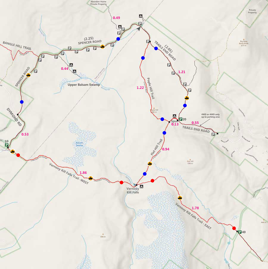
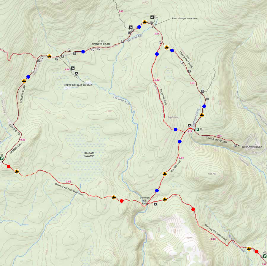
    DIRECTIONS to TRAIL HEAD ROAD from Exit 19 (Kingston)

     
  • Spencer Road Parking Area WGS84 (DEC): 41.895633, -74.389283 - Elevation is approximately 1,961 feet
  •  
  • Spencer Road Parking Area Deg/Min/Sec: N41 53 44, W74 23 21 - Elevation is approximately 1,961 feet
  •  
  • Spencer Road Parking Area GPS: N 41 53.738, W 74 23.357 - Elevation is approximately 1,961 feet
  •  
  • Spencer Road Parking Area UTM: 18N 550661 4638369 - Elevation is approximately 1,961 feet
  •  
     
  • Take New York State Thruway to Exit 19 (Kingston).
  •  
  • Take a RIGHT out of the NYS Thruway to Route 28 West.
  •  
  • Go approximately 0.4 miles on Rt 28 West
  •  
  • Take a RIGHT off the ramp for Rt 209 South
  •  
  • Go approximately 11.6 miles on Rt 209 South
  •  
  • Take a RIGHT onto Rt 2 (Krumville)
  •  
  • Go approximately 8.2 miles on Rt 2
  •  
  • At the End of Rt 2 - Continue onto Rt 3
  •  
  • Go approximately 1.7 miles on Rt 3
  •  
  • Take a RIGHT onto Sundown Road (which turns into Trails End Road)
  •  
  • Go approximately 2.5 miles
  •  
  • The two-lane road turns into a one-lane road when you reach DEC land
  •  
  • Go approximately 3.2 miles up the one-lane dirt road.
  •  
  • (2) Parking Area before and after the road to Upper Balsam Swamp.


  • MILEAGE CHART from DEC PA to VERNOOY KILL LOOP

      Mile PointAltitudeNotes
      0.00 1,961' Road into the interior loop
      0.44 1,805' Upper Balsam Swamp

    Hike to Vernooy Kill Loop from TRAILS END ROAD in the Sundown Wild Forest

    Campsite #1 above Upper Balsam Swamp and below spencer road
    About 0.21 miles down the non-maintained road to the interior of Balsam Swamp region, you will encounter your first campsite. It is the largest campsite. It can handle several tents. PLEASE do not leave garbage at the campsite. There is a second campsite another 1/10 mile down the road.
    Upper Balsam Swamp


    Upper Balsam Swamp
    At 0.44 miles down the non-maintained trail you will come to a clearing with high-grass. In the middle is a small water body. As of 2023, there was a beaver in the Upper Balsam Swamp.
    aerial view of Upper Balsam Swamp in the Vernooy Kill Falls region
    This is an aerial view of Upper Balsam Swamp in the Vernooy Kill Region. If the temperatures are below 50F you can hike over to the larger swamp or explore other areas. This should be done with a partner.

    LINKS & REFERENCES for the Upper Balsam Swamp

     
    USGS Peekamoose Quad Maps
     
    USGS West Shokan Quad Maps
     
    USGS Rondout Reservoir Maps
     
    USGS Kerhonkson Quad Maps
     
    DEC Trail Map
     
    DEC Unit-Management-Plan for Sundown Wild Forest
     

      S E C T I O N S


      W E A T H E R


      O T H E R

    Copyright 1994-2024 www.catskillmountaineer.com ALL RIGHTS RESERVED