Balsam Cap Mountain & Friday Mountain
|
|
|
|
Overview of this Hike: |
| Distance: 7.69 miles from Moon Haw Road. |
| Time: Average 7.00 hours round trip |
| Elevation Gain: 2,408 for Balsam Cap and another 405' from Route #1 (286
fro Route #2). |
| Best Time to Hike: Morning. |
| Difficulty: Difficult |
| VO Map No: THIS IS A BUSHWHACK HIKE! |
| Peak Elevation: 3,606' (BC) and 3,660' (Friday) |
| Digital Mapper (BC):
Topo
Terrain
Satellite |
| |
| Digital Mapper (Friday):
Topo
Terrain
Satellite |
| Access Methods: Foot & snowshoe |
|
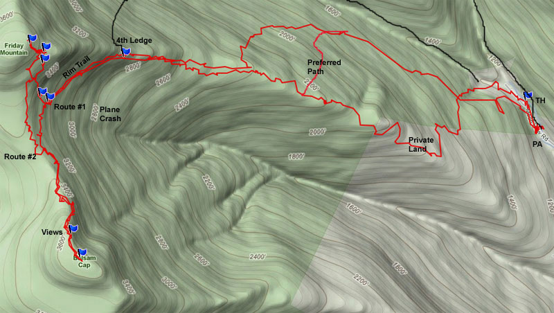
Maps, Profile, and GPS files |
 |
|
|
|
Directions to Trail Head from New York State Thruway (Easist, not the shortest): |
| GPS Coordinates to 1st Parking Area: N41 59.023 W74 19.614 - Elevation is approximately 1,198 feet |
| Take New York State Thruway to Exit 20 (Saugerties). |
| Take Rt 212 to Woodstock. |
| Take Rt 375 to Rt 28. |
| Go approximately 10.1 miles west on Rt 28 |
| Take a left onto Rt 28A (Reservoir Road) just before Boiceville |
| Go 2.9 miles South on Rt 28A |
| Take a RIGHT onto Rt 42 - Go 0.8 miles on Rt 42 |
| Take RIGHT onto Moonhaw Road |
| Go 2 miles on Moonhaw Road - Be careful not to continue on to Dry Brook Road. |
| After you go over a one-lane bridge, there are 3 parking areas before private residence. |
| Do NOT block private residence - Do NOT block snow plows from turning around. |
| These parking areas are not official DEC Parking lots, and they are not marked. |
|
Special Circumstances about this Hike |
|
This hike has almost 3,000' of vertical, and route finding is exceedingly difficult. While there are a lot of old logging roads on the mountain side, finding the correct route is difficult. About 25-30% of the hikers don't summit both mountains. Friday Mountain causes most of the problems. The beginning of the hike is also difficult. Because of the large number of logging roads, it is hard to determine which ones to take. Some maps show some of them, but no maps show all of them. Some hikers accidently venture onto private land.
In the beginning of the hike many people have difficulties trying to determine which logging roads to take. We hope to help you select the best routes. Some just ignore them, and move up the ridge line. One problem that does happen is that people move too far to the left and venture onto private land. There are houses way up in the mountains, and they don't like hikers visiting them. Some maps show the private land, and some don't. The land boundry is NOT marked. If you get close to the log cabin, you might see Private Property signs.
Once you get onto the Friday Ridge line, the best way to move up the ridge line is to stay on the left side of the ridge line. As you move up the ridge, you will encounter bigger and more imposing ledges. Finally when you get to 3,000' you will come to a large ledge that is 50-100' high. You will be force to move to the left side of the ridge. Once you get on the left side of the ledge, you will see the Rim Trail. On the maps the Rim Trail looks difficult and imposing. But, in reality, it is an easy trail that moves up 300 vertical feet over 3/4 of a mile. The Rim Trail moves up smoothly and gradually. Actually the easist part of the hike. It only looks imposing on the map. As you move up the Rim Trail, you will see ledges up the hill from the trail. There are two breaks in the ledges above the Rim Trail. You can use either opening of this ledge to access Friday Mountain.
I usually hike Balsam Cap Mountain before Friday. It is easier to find. Once you follow the Rim Trail up to the col between Friday Mountain and Balsam Cap Mountain, the common sense thing to do is to get onto the col. But, this is not the best route to Balsam Cap Mountain. It is best to continue to follow the Rim Trail until you are almost on top of Balsam Cap. While following the Rim Trail from the col to Balsam Cap Mountain, the trail will move up and down in elevation. The herd trail will make many twist and turns. Sometimes it is hard to follow. When the trail gets difficult and becomes too dangerous to follow, you will need to move up on the ridge. But, you should try to stay on most easterly side of the ridge. The 3500 canister is located 50-100' from the ledge. Just before you get to the canister, you will come to a very nice ledge to get views of the Ashokan Reservoir, Devil's Path, and Cornell/Wittenberg. The canister is located about 100' from the true summit of Balsam Cap. Once you get done, return back to the col on the same route.
There are two common routes to the top of Friday Mountain. Both have difficult problems and route finding problems. Before I discuss routes, you need to know that Friday Mountain is loaded with ledges, and many of these ledges are very high. Fall off one of these ledges, and you may be killed. Routes up through some of the ledges are difficult. Most of the routes are dangerous. But, a small number are somewhat safe.
Route #2 to Friday Mountain has 286' of vertical ascent. It has two major ledge ascents. The drawback to this route is that you must bushwhack through dense balsam fir trees to get to the base of Friday Mountain. It can be frustrating to get through. There is no defined herd path from the col to the base of Friday Mountain. Lots of twist and turns. Not terrible, but slow going. When you approach the southern side of Friday Mountain, you will encounter your first major ledge. It is about 100' high. You need to walk around the base of Friday Mountain. You want to move to the easterly direction. Look for the best opening in the ledge. Many are dangerous and risky. But, if you take your time, you will find a relatively safe route up through first ledge. I used one route that moves sideway up the ledge. Once you get up the first ledge, you will see the next 100' ledge. Move around to the middle of the easterly side of Friday Mountain. When you get to the middle of the easterly side, you will see a 50-100' opening of the ledge. This is the best route up. You will see a number of smaller balsam fir trees in the middle. The left side of the access is about 45 degrees. The right side of the access is about 30 degrees. So, move to the right side of the opening. Once you get up to the top of the ledge there is a view point on the other side of the ledge. Not a great view point. You will then hike up a short ways to the top of the mountain. The canister is located on the very easterly side of the mountain summit. It is NOT on the true summit of the mountain. Some people have missed the canister as they move to the true summit. The canister is quite a ways from the true summit.
Route #1 to Friday Mountain has 405' of vertical ascent. This route has 4-5 ledge ascents. This is the drawback to this route. But, the route is easier to hike then Route #2. The disadvantage is finding the beginning of the route. Unless you are told how to find the beginning of the route, you will probably have an extremely hard time finding it. Hopefully, we should make this easier to find. If you have a GPS, this should make it easier. But, you can do it without a GPS. After you return from the summit of Balsam Cap Mountain to the col, you want to continue another 0.23 miles down the Rim Trail. When you see two very large boulders that looks like a large and smaller whale, this is the access to Route #1. Just before you get to the "Whale Rocks", turn left and walk directly up hill. Once you get to Friday Mountain base, you will see a hikable route. Once you start going up, you will turn 90 degrees to the right, and will follow a 50-100' ledge uphill at a moderate rate. Continue in this direction. Once you get to 3,500' you will need to turn left and move up the opening in the upper ledge. I always looks for the triangluar arch tree. When you get to the middle of the easterly side, you will see a 50-100' opening of the ledge. This is the best route up. You will see a number of smaller balsam fir trees in the middle. The left side of the access is about 45 degrees. The right side of the access is about 30 degrees. So, move to the right side of the opening. Once you get up to the top of the ledge there is a view point on the other side of the ledge. Not a great view point. You will then hike up a short ways to the top of the mountain. The canister is located on the very easterly side of the mountain summit. It is NOT on the true summit of the mountain. Some people have missed the canister as they move to the true summit. The canister is quite a ways from the true summit.
There is also a plane crash near Friday Mountain. It is located in between the ridge lines between Friday Mountain ridge line and Balsam Cap Mountain ridge line. It is located around 2,700' (+-100'). It is located down near the creek, but on the Friday Mountain side. Most people access it from around 3,000' on the Friday Mountain ridge line. This is a B-25 Air Force plane. The plane crashed on the evening of March 31, 1948. Two victims were found. A third victim was never found. Most of the twin engine plane are still on site. It was built in 1944 and was used in France during WWII. Please do NOT remove or move any of the debris. This deeply upsets the victim's family when this happens. It has a number of 44-29215.
|
| Mile Point | Altitude | Notes |
| 0.00 | 1,198 | DEC Parking Lot - GPS: N41 59.023 W74 19.614 |
| 0.14 | 1,215 | Start of Trail. |
| 1.78 | 2,550' | 1st Ledge on Friday Ridge Line |
| 1.92 | 2,700' | 2st Ledge on Friday Ridge Line |
| 2.00 | 2,800' | 3st Ledge on Friday Ridge Line |
| 2.10 | 2,934' | 4st Ledge on Friday Ridge Line |
| 2.54 | 3,250 | Whale Rocks - Access #1 to Friday Mtn - GPS: N41 59.095 W74 21.591 |
| 2.77 | 3,374 | Col between Balsam Mtn and Friday Mtn |
| 3.25 | 3,597 | Great view point 500' from the summit of Balsam Mtn |
| 3.36 | 3,606 | Cannister on summit of Balsam Mtn - true summit is 100' further south |
| 3.95 | 3,374 | Return to the Col between Balsam Mtn and Friday Mtn |
| 4.18 | 3,250 | Return to the Whale Rocks - Access #1 to Friday Mtn - GPS: N41 59.095 W74 21.591 |
| 3.94 | 3,374 | Return to the Col between Balsam Mtn and Friday Mtn |
| 4.60 | 3,660' | Hike to Friday Mtn using Route #2 |
| 7.69 | 1,198 | Return using Route #1 - Return to Parking Lot |
| Mile Point | Altitude | Route #1 up to Friday Mountain from Whale Rocks |
| 0.00 | 3,250 | Whale Rocks - Access #1 to Friday Mtn - GPS: N41 59.095 W74 21.591 |
| 0.06 | 3,336 | Hike up to the Rim Ledge - Lower Ledge - GPS: N41 59.110 W74 21.621 |
| 0.25 | 3,468 | Middle Ledge - GPS: N41 59.209 W74 21.612 |
| 0.29 | 3,512 | Base of upper ledge - GPS: N41 59.245 W74 21.606. |
| 0.52 | 3,660 | Cannister on Friday Mtn - GPS: N41 59.270 W74 21.662 |
| Mile Point | Altitude | Route #2 up to Friday Mountain from Col |
| 0.00 | 3,250 | Whale Rocks - Access #1 to Friday Mtn - GPS: N41 59.095 W74 21.591 |
| 0.66 | 3,660 | From Col to the Cannister on Friday Mtn - GPS: N41 59.270 W74 21.662 |
| 1.18 | 3,250 | Return to Whale Rocks using Route #1. |
|
|
Hike to Balsam Cap and Friday Mountain |
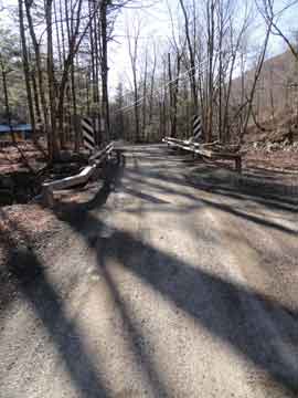 |
After you drive over the one-lane bridge on Moonhaw Road, there will be 3 areas where you can park. All three areas are on the RIGHT side of the road. The first area is just after the bridge can park 5 cars. The second area is across the street from the Trail Head, and it can park 2 cars. The third area is next to the gates to someones house. This area can park a couple cars.. |
|
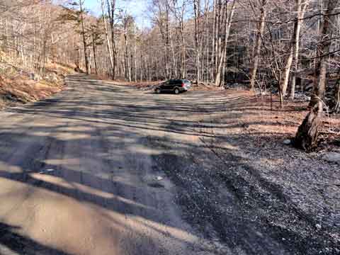 |
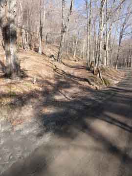
This picture shows the first parking area on Moonhaw Road. The Trail Head to Balsam Cap and Friday mountain are 0.14 miles up Moonhaw road from this parking area. You may notice another trail across the stream. This trail will not take you to Balsam Cap or Friday mountain. |
|
 |
The trail head is on the LEFT side of Moonhaw Road. It is across the street from the 2nd parking area (2 car space).
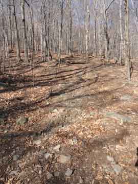
The trail immediately heads up the steep hill. The trail is an old logging road. You will notice that there are numerous other logging roads running across the trail. Part way up, you are going to want to take a LEFT off this road. The best way to know which road you want to take is to look for a large rock on the left side of the intersection. The rock is approximately 1-1/2 to 2' high and about 4' in diamter. When you find this rock, take a RIGHT on the logging road. This will lead you to the RIGHT side of the Friday Ridge Line. The trail will be fairly flat. After a while, it will turn 90 degrees and climb steeply up to the top of the Friday Mountain Ridge. Once on top, you want to turn 90 degress RIGHT and climb up the ridge. |
 |
|
 |
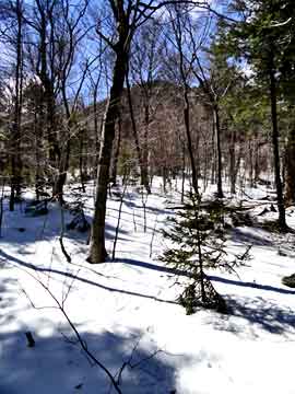
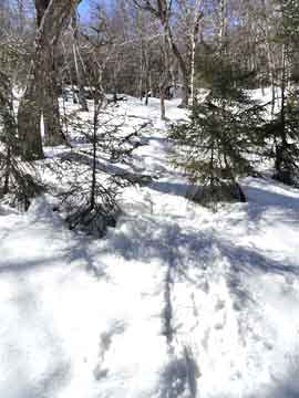
When you arrive at the top of the Friday Mountain Ridge, you will have a fairly flat walk up an easy ridge line. Initially, you will come up into a nice spread out conifer forest. You will then walk in-and-out of conifer forest as you walk up the ridge. Below the ridge is some private land. There is a cabin around 2,000' and the owners don't like visitors, so try to stay away from their land.
As you start to walk up the ridge you will hit your second set of ledges. It is located at 2,700'. The first set of ledges is around 2,550'. The first set is just a small rise. The first one in the picture is pretty easy to get around. We recommend that at this point you move to the LEFT side of the ridge. Eventually, you will be required to go to the very left side of the ridge to get up to Balsam Cap and Friday mountains. Might as well start now. |
|
 |
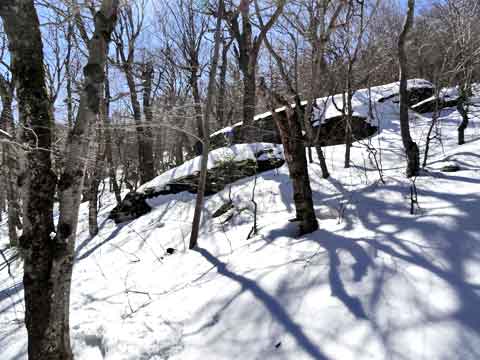
This is the next set of ledges. Obviously, this one is more difficult. It is located at 2,800'. But, if you are on the left side of the ridge line, you can pass it quite easily. Remember to stay to the LEFT side of the ridge. |
|
 |
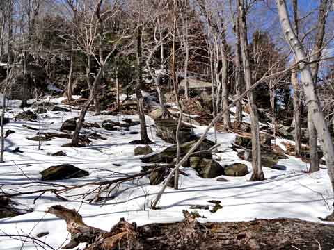
As soon as you walk past the 3nd set of ledges, you will see the next set of ledges. It is large and difficult. To get past the next set of ledges, you MUST move to the very LEFT side of the ledges to continue. |
|
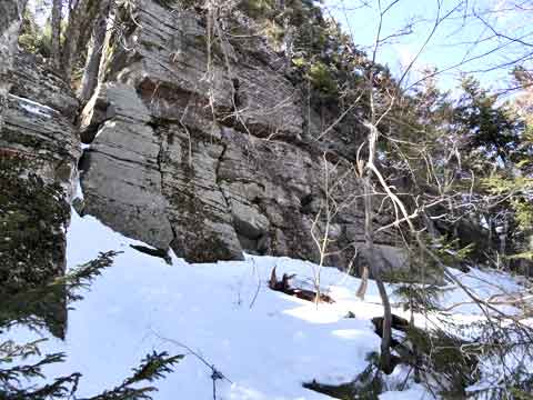 |
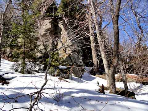
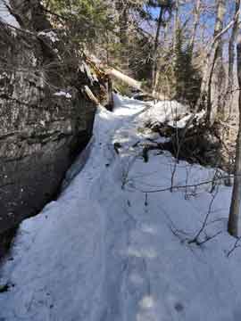
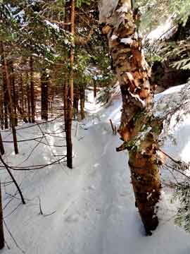
When you arrive at the 4rd set of ledges, you will discover that this ridge line is about 50' high. It is located at 2,934'. The only way around it is to go on the LEFT side of the ledges. The ledges will follow you all the way up to Friday Mountain and Balsam Cap mountain. It is really called a Rim Ledge that surrounds the two mountain's escarpment. There are two openings further up the Rim Trail. You can use one or both openings to access Friday Mountain and Balsam Cap Mountain. These openings are not so easy to find. We will help you.
You will find an established trail on the very left side of the ridge line.
|
|
 |
This is a picture of the Rim Trail just past the 4rd set of ledges. On trail maps, this trail looks difficult. But, the grade is very gradual, and a fairly easy walk. If you plan on taking the first route up Friday Mountain, and you have a GPS, start measuring your milage at the 4th ledge. |
|
 |
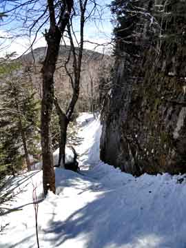
At 0.44 miles past the 4th ledge, you will come to a set of rocks, that some call the "Whale Rocks". You might be a little low or high on the trail, so keep your eye out for the rocks. As soon as you pass the rocks, turn 90 degrees to the RIGHT, and climb straight up the hill. As you approach the Rim Ledges, you will see a chute that moves up the side of the ledges. Friday Mountain is 405' climb from the Rim Trail to the Canister on Friday Mountain.
The rocks are located at 3,250' and the GPS waypoint is: N41 59.095 W74 21.591. At this GPS coordinate, turn 90 degress and hike up the hill. |
|
 |
From just past the Whales Rock, this is the view up to the Rim Ledge just below Friday Mountain. The GPS point where this picture was taken is N41 59.095 W74 21.591, and the elevation of 3,250'
Once you walk up Rim Ledge look for a route up the side of the ledges. Look for elevation of 3,336' with GPS coordinates of: N41 59.110 W74 21.621 . |
 |
|
 |
This is a picture looking back as you climb up the ledges. You can see Balsam Cap Mountain in the background.
This is a picture about 1/2 way up Friday Mountain. It is located at 3,468' and has GPS coordinates of: N41 59.209 W74 21.612 . Once you get above this small chute, you will be below the upper ledge. You will have to walk a short distance to find the chutes above the upper ledge. |
 |
|
 |
Once you get up to the upper ledge, the last chute up to the top of Friday Mountain is the one where most people have a difficult time. It is at elevation of 3,512' with GPS coordinates of: N41 59.245 W74 21.606. One trick to finding this hidden chute is to look for the Arching Branch in the picture. Eventually, the branch will be gone. But, for right now it is helpful. Many people have a problem finding this chute.
If you look at the LEFT side of the picture, you can see the 50-100' ledge wall (barely visible in the picture). On the RIGHT side of the picture you can see the 75' Ledge wall (barely visible in the picture). In the middle of the picture you can see a number of small balsam fir trees. There are two chutes up this opening. On the LEFT side of the balsam trees is a 45 degree chute that will climb up 100 vertical feet. on the RIGHT side of the balsam trees is a 30 degree chute that will climb up 100 vertical feet. Stick to the RIGHT side, and climb up the RIGHT chute. The left chute is very difficult to climb with snowhsoes. The right chute is easy to climb with snowshoes.
|
|
 |
This picture is taken on the left side of the left chute on the upper ledge. You need to be careful getting over to the top of this ledge. Most people are too tired to climb over, so most people skip taking a picture of this limited view. |
|
 |
Once above the upper ledge, the trail is pretty easy to get to the summit of Friday Mountain in the Catskill Mountains. The cannister is located on the center of the easterly side of the summit of Friday Mountain. It is located at 3,660' at GPS coordinates: N41 59.270 W74 21.662 .
The cannister is located a long way from the actual summit of Friday Mountain. The actual summit is located at GPS coordinates of: N41 59.15, W74 21.44 . The actual summit is located near the middle of the summit peak. The summit of Friday Mountain is known for having dense balsam fir trees, so beware that you may have to push through them. People who have tried to access Friday from Cornell Mountain have encountered some of these dense fir trees, and find them memorable difficulty.
Return back down the same route back to the Rim Trail. If you are going to summit of Balsam Cap Mountain, continue up the Rim Trail. |
|
 |
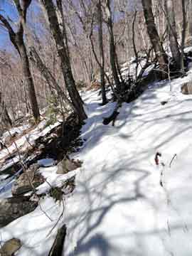
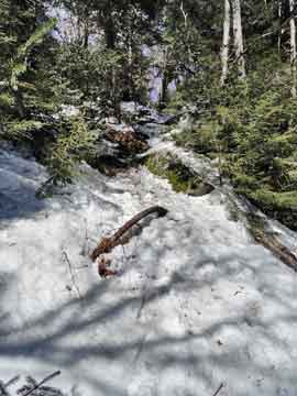
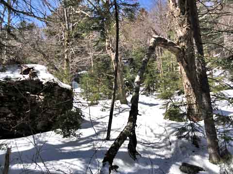
After you walk a little further up the Rim Trail, you will come up very close to the Rim Ledge, and you will enter into a tight balsam fir tree forest. This picture was taken next to Route #2 to Friday Mountain. But, to get to Balsam Mountain, you want to continue on the Rim Trail almost all the way to the top of Balsam Mountain. At time you will go up and down in elevation as you approach Balsam Mountain. When you get close to the summit, you will have to walk up a steep hill to get to the top.
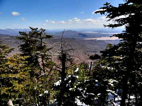
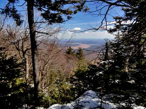
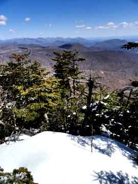
Once you are very close to the summit, you will come to a very nice view. This picture shows the middle of the view point with the Devil's Path in the background.
|
 |
|
 |
This is the view to the LEFT of the view point. In the picture you can see Cornell mountain and Wittenberg Mountain. Very nice view on a good day.
|
|
|
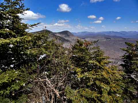
This picture was taken from the Great view point on Balsam Cap Mountain. The Devil's Path on the left side of the picture. The Ashokan Reservoir is on the right side of the picture. |
|
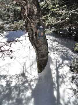 |
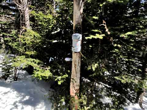
This is the cannister on the summit of Balsam Cap Mountain. It is located 500' south of the great view point. The true summit is located 100' past the cannister. It is gray in color and very difficult to see. It is attached to a Birch Tree on the north side of the tree.
There is another view point about 500' to the south of the summit of Balsam Cap Mountain. To get to this view point, you will have to descend about 225-250' vertical feet.
A second view point if located about 2500' south of the summit. To get to the second view point south of the summit of Balsam Cap, you will have to descend about 100-150' past the first view point AFTER the summit, and then reascend 100-150' vertical feet.
|
|
|
After you return back to this point, you can climb Friday Mountain on Route #2. At this point in the picture, you will enter into the col and push your way through the balsam fir trees towards Friday Mountain. Route #2 is 286' vertical climb to the summit of Friday Mountain. Once you reach the base of Friday Mountain, you will come to some 100' ledges. These are the middle ledges. Walk to the south-east side of Friday Mountain. Look for a side route up the the middle ledges. It will require some searching to find the safe route up the middle ledges. Do NOT take any risky route up the middle ledges.
This will put you on the bottom of the upper ledges. You will then need to walk around to the middle of the easterly side of the upper ledges to find the chutes.
|
|
|
Once you get up to the upper ledge, the last chute up to the top of Friday Mountain is the one where most people have a difficult time. It is at elevation of 3,512' with GPS coordinates of: N41 59.245 W74 21.606. One trick to finding this hidden chute is to look for the Arching Branch in the picture. Eventually, the branch will be gone. But, for right now it is helpful. Many people have a problem finding this chute.
If you look at the LEFT side of the picture, you can see the 50-100' ledge wall. On the RIGHT side of the picture you can see the 75' Ledge wall. In the middle you see a number of small balsam fir trees. There are two chutes up this opening. On the LEFT side is a 45 degree chute that will climb up 100 vertical feet. on the RIGHT side is a 30 degree chute that will climb up 100 vertical feet. Stick to the RIGHT side, and climb the RIGHT chute. The left chute is very difficult to climb with snowhsoes. The right chute is easy to climb with snowshoes.
|
|
|
This picture is taken on the left side of the left chute on the upper ledge. You need to be careful getting over to the top of this ledge. Most people are too tired to climb over, so most people skip taking a picture of this limited view. |
|
|
Once above the upper ledge, the trail is pretty easy to get to the summit of Friday Mountain in the Catskill Mountains. The cannister is located on the center of the easterly side of the summit of Friday Mountain. It is located at 3,660' at GPS coordinates: N41 59.270 W74 21.662 . The cannister is located a long way from the actual summit of Friday Mountain. The actual summit is located at GPS coordinates of: N41 59.15, W74 21.44 . |
|
|
S E C T I O N S
|
W E A T H E R
|
O T H E R
|