Catskill Mountaineer

Countryman Kill Falls #1

countryman kill falls


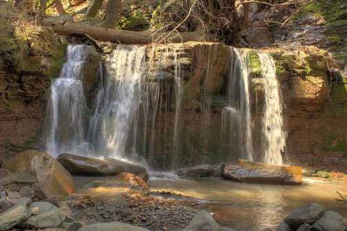
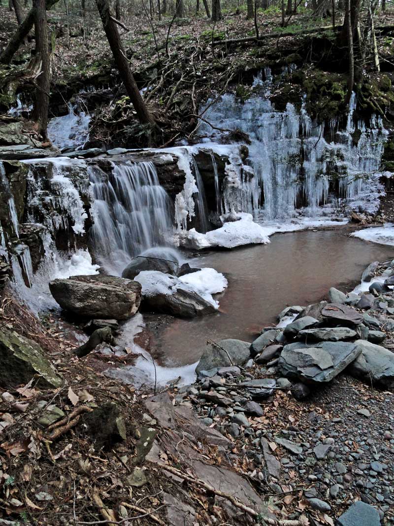
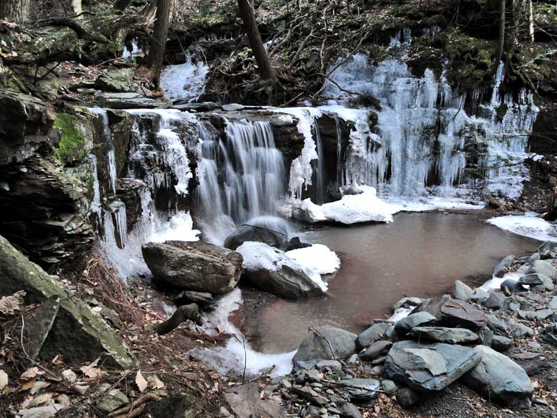
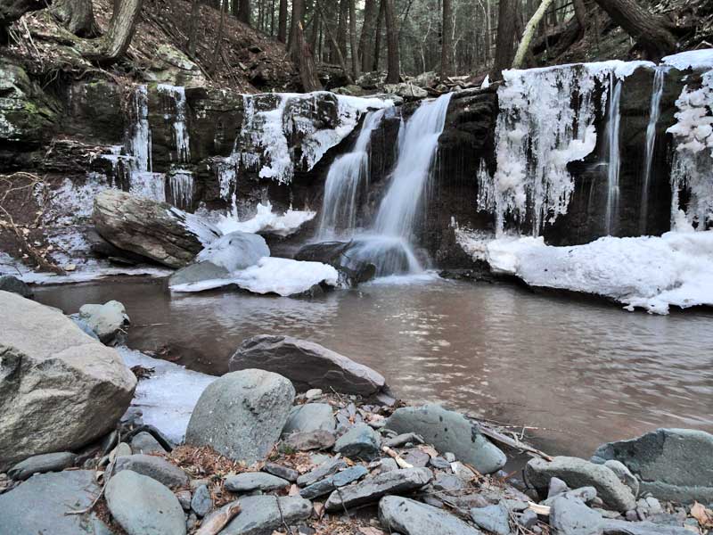
Information about Countryman Kill Falls #1:

Name: Countryman Kill Falls
County: Greene
Region: Eastern Escarpment / North-South Lake
Location: Countryman Kill Creek
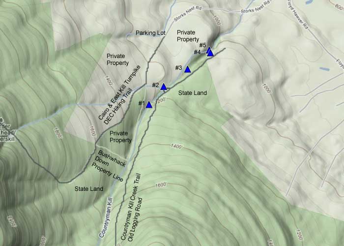
Order within ravine: 1st of 5 waterfalls (1=highest elevation)
Order within waterfall: 1 of 1 (1=highest elevation)
Total Height: 45' (GPS in 2012)
Top Elevation: 1,234
Bottom Elevation: 1,219
Type of Waterfall: Cascade & Plunge
Number of Drops: 1
GPS location:N42 14.880, W74 03.312 (Top of falls)
WGS84 location:42.248, -74.0552 (Top of falls)
Lat Long location:N42 14 52, W74 03 18 (Top of falls)
UTM location: 18N 577942, 4677744 (Top of falls)
Named: 2012
Previous or Alternate Names: none known
Description: This is the first
Hiking Distance: ~2 miles (round trip) from Stork Nest Road. ~4 miles from the Winter Clove Inn.
Hiking Distance from Trail: 1/4 mile
Time: Average 1.5 hours round trip
Elevation Gain: 500 from Stork Nest Road.
Elevation Loss: 500 from DEC trail to falls.
Difficulty: Hike down to Countryman Creek is slightly steep. - Must cross Creek to get to State land
Difficulty: The creek can ONLY be crossed at low water!
Final access to top of waterfalls: Hike down steep bank
Final access to bottom of waterfalls: Hike down steep bank
Digital Mapper: Topo      Terrain      Satellite
Known Access Safety: Steep banks down into Creek


Maps

map of countryman kill falls


Directions to Trail Head from New York State Thruway (Easist, not the shortest):

  • Take New York State Thruway to Exit 21 (Catskill).
  • Take a left out of the NYS Thruway entrance road.
  • Go approximately 1/4 mile
  • Take a right onto Route 23 West
  • Go approximately 10.7 miles on Rt 23 (past Cairo, NY and up the hill towards Windham)
  • Take a left onto Route 31 to Round Top, NY
  • Go approximately 3.7 miles on Rt 31
  • Take a RIGHT onto Maple Lawn Road
  • Go approximately 1.3 up Maple Lawn Road.
  • At the top of the hill take a LEFT onto Floyd Hawver Road.
  • Go approximately 200'
  • Take a RIGHT onto Stork Nest Road
  • Follow Stork Nest Road to the very end (0.6 miles)
  • Park on the left side - Do NOT go up the driveway.
  • Parking lot holds 5 cars.
  • GPS: N42 15.177 W74 03.199 - WGS84: 42.25295, -74.053317 for Parking Lot


  • Comments about this Hike

    These waterfalls are the forth of five waterfalls on the Countryman Kill Creek. They are also the highest waterfalls of this group. The fifth waterfalls is at the bottom of the pool of the forth waterfall. Technically, the forth and fifth waterfall are considered one waterfall. Both the forth and fifth waterfall are difficult to get down to. If the water level is high, then you will have to access the Falls from Winter Clove Inn (see link on bottom of page).

    Hiking Directions: To get to these waterfalls, you need to hike up the DEC trail about 3/4 of a mile. When you come to the DEC marker, you will need to leave the trail and start bushwhacking. Take a 90 degree turn and walk down the steep banks towards the creek. When you reach the creek, move up the creek a little ways until you find an easy way to get down into the creek. At this point, you can cross the creek. NOTE: You should only cross the creek at low water. Once you cross the creek, you will find an old road a little ways from the creek. Then turn 90 degress to the LEFT and walk down hill and parallel to the creek.

    Alternate Hiking Directions: Drive to Winter Clove Inn. Get permission from the front desk. They can also provide directions of how to get the Countryman Kill Falls. Park your car in a place that will not inconvenience hotel guest. The trail begins on the RIGHT side of the hotel. Walk towards the creek. Then walk across the covered bridge (Artist Falls below the bridge). Walk up the trail a ways. Please note that there are many trails in the beginning. Then take a right to walk to the Countryman Kill Creek. It is a 2 mile hike to the Falls.

    NOTE: Do NOT cross private property to get to these waterfalls. The local land owners are very sensitive about people who trespass on their property. Please take the DEC trail up to DEC land. Please follow our instructions on hiking to these waterfalls.


    Mile Post Chart

    Mile PostAltitudeNotes
    0.001,130’ Parking lot. GPS: N42 15.177 W74 03.199
    0.331,253' DEC registration box.
    0.791,620' NYS Land on both sides of the trail. - Take LEFT and bushwhack down to Countryman Kill Creek
    ~1~1,400' Cross Countryman Kill Creek.
    ~1.51,234' Take road down the right side of the creek
    ~3.01,130’ Return to Parking Lot

    Pictures of Countryman Kill Falls #1


    countryman kill falls #1 in the catskill mountains
    Countryman Kill Creek
    Photo by Catskill Mountaineer


    countryman kill falls #1 in the catskill mountains
    Countryman Kill Creek
    Photo by Catskill Mountaineer


    countryman kill falls #1 in the catskill mountains
    Countryman Kill Creek
    Photo by Catskill Mountaineer


    countryman kill falls #1 in the catskill mountains
    Countryman Kill Creek
    Photo by Catskill Mountaineer
    Links and References:
     
    Winter Clove Inn (trail access)

      S E C T I O N S


      W E A T H E R


      O T H E R

    Copyright 1994-2024 www.catskillmountaineer.com ALL RIGHTS RESERVED