|
Information about Lucas Kill Falls #1: |
| Name: Lucas Kill Falls #1 (No proposed name) |
| County: Greene |
| Region: Eastern Escarpment on the Kaaterskill Mountain Range |
| Location: Lucas Kill Ravine |
| Order within ravine: 1st of x drops (1=highest elevation) |
| Order within waterfall: 1 of 1 (1=highest elevation) |
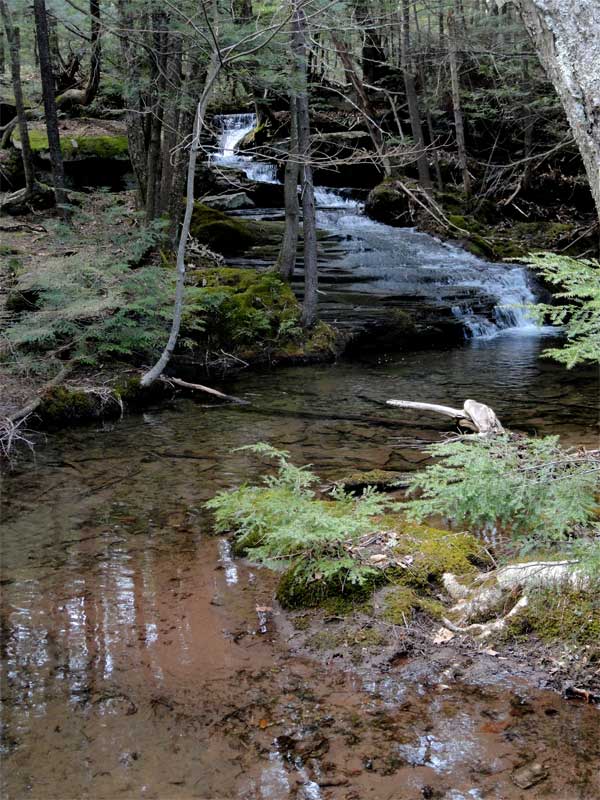
| Total Height: 15' (measured by GPS in 2011) |
| Top Elevation: 2320 |
| Bottom Elevation: 2305 |
| Type of Waterfall: Cascade |
| Number of Drops: 1 sloping cascade |
| GPS location: N42 08.326 W74 03.471 (Top of falls) |
| Named: N/A |
| Previous or Alternate Names: none known |
| Description: This is a gentle cascade that is idylic and beautiful. Clearly, not a big waterfall, but it is the kind of waterfall you could sit next to all day. |
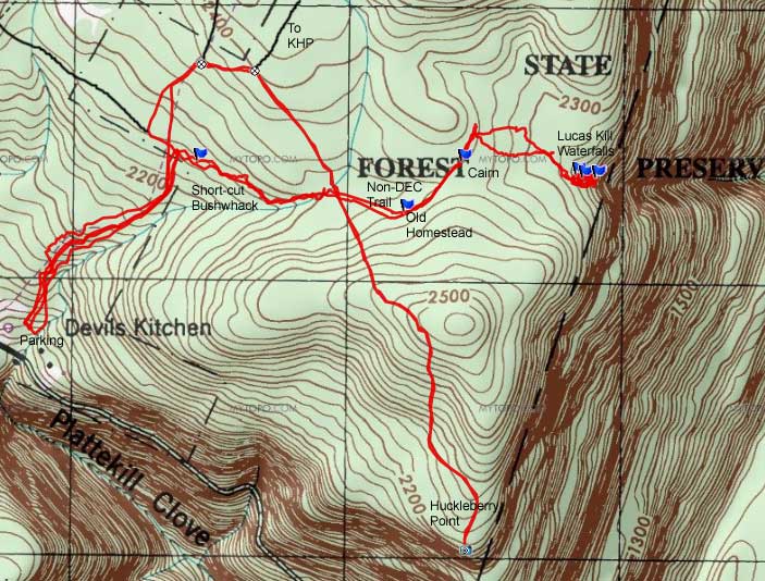
| Hiking Distance: ~3-5 miles (round trip) from the DEC Devil's Kitchen Parking Lot. |
| Hiking Distance from Trail: 1 mile - After crossing Hell's Hole Creek, the trail is 50' on the left. |
| Trail Information: Huckleberry Point |
| Time: Average 3 hours round trip |
| Elevation Gain: 400 from Rt 16. |
| Difficulty: Intermediate - but there is some bushwhacking |
| Final access to top of waterfalls: Hike |
| Final access to bottom of waterfalls: Hike |
| Digital Mapper:
Topo
Terrain
Satellite |
| Known Access Safety: Mossy and slippery rocks on cascade |
| Known Access Safety: Very dangerous at high water (crossing Wildcat Creek) |
| Access Methods: Hike |
|
|
Directions to Trail Head from New York State Thruway (Easist, not the shortest): |
| GPS Coordinates to Parking on Platte Clove Road: GPS N42 08.041 W74 04.918 - Elevation 1,950' |
| Take New York State Thruway to Exit 21 (Catskill). |
| Take a left out of the NYS Thruway entrance road. |
| Go approximately 1/4 mile |
| Take a right onto Route 23 West |
| Go approximately 6.6 miles to Cairo, NY |
| Take a LEFT onto Rt 32. McDonalds Rest. on corner. |
| Go approximately 7.7 miles on Rt 32 |
| Take a RIGHT onto Rt 23A |
| Go 9.0 miles on Rt 23A . |
| When you come into Tannersville, take LEFT at the red light onto RailRoad Ave (Rt 16), which will turn into Spruce Street, which will turn into Platte Clove Road. Follow this road approximately 7-8 miles |
| The parking lot is on the LEFT side of the road. Look for the DEC sign next to a small driveway |
| It is approximately 1/3 mile past Josh Road (on right side of the road). GPS N42 08.041 W74 04.918 - Elevation 1,950' |
| Mile Point | Altitude | Notes |
| 0.00 | 1,872 | DEC Parking Lot. N42 08.020 W74 04.962 |
| 0.89 | 2,366 | Road & Trail Junction - On Right side of road - easy to miss this junction - N42 08.553 W74 04.467. |
| 1.21 | 2,412' | Trail Junction - Left goes to Kaaterskill High Peak - Right goes to Huckleberry Point - N42 08.544 W74 04.325 |
| 1.55 | 2,375' | Turn LEFT on unmarked trail 50' after corssing Cross Hell's Hole Creek - N42 08.290 W74 04.109 |
| ~2.00 | 2,398' | Look for rock cairn on right side of trail (old property marker) - GPS: N42 08.353 W74 03.773 |
| ~2.05 | 2,398' | Continue a little bit longer - But, do not walk past large tree across the road. |
| ~2.25 | 2,320' | Turn RIGHT and walk downhill and follow water streams to Lucas Kill Falls - GPS: N42 08.326 W74 03.471 |
| 4.50 | 1,950 | Return to Parking Lot |