Kaaterskill Wild Forest |
|
|
 Long Path Long Path |
 Harding Road Trail Harding Road Trail |
 Huckleberry Point Trail Huckleberry Point Trail |
 Escarpment Trail Escarpment Trail |
 Schutt Road Trail Schutt Road Trail |
 Poets Ledge Trail Poets Ledge Trail |
| |
 Palenville Overlook Spur Trail Palenville Overlook Spur Trail |
 Harding Road Spur Trail Harding Road Spur Trail |
| |
 Sleepy Hollow Trail Sleepy Hollow Trail |
 Yellow Horse Trail Yellow Horse Trail |
| |
|
 Yellow Crossover Trail Yellow Crossover Trail |
 Kaaterskill Trail (formally SMT) Kaaterskill Trail (formally SMT) |
|
 Observation Deck Trail Observation Deck Trail |
 KHP Trail (north) KHP Trail (north) |
|
 Kaaterskill Falls Trail Kaaterskill Falls Trail |
 KHP Trail (south) KHP Trail (south) |
|
 Kaaterskill Rail Trail Kaaterskill Rail Trail |
|
 Huckleberry Quarry Trail Huckleberry Quarry Trail |
 Lucas Kill Trail Lucas Kill Trail |
 Western KHP Trail Western KHP Trail |
 Twilight Park Trail Twilight Park Trail |
 Hawkeye Ledge Trail Hawkeye Ledge Trail |
 Palenville Quarry Trail Palenville Quarry Trail |
 Indian Camp Spur Indian Camp Spur |
 Brant Fort Trail Brant Fort Trail |
 DEP-SMT Spur DEP-SMT Spur |
|
| |
| |
|
Brant Fort Camp 7.30 miles round trip from DEP Parking Lot #1 - 5 hours round trip. Historic Hike.


|
|
| |
| |
|
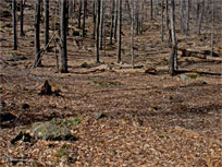
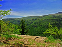
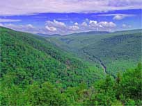
Escarpment Trail - Southwest Section - 4.04 to 4.58 miles round trip - 3-4 hours. Easy hike. Encounter Layman's Monument, 4 un-named ledges overlooking Kaaterskill Clove, Sunset Ledge, and Inspiration Ledge. Numerous side trips (Kaaterskill Falls, hotel, etc.). Outstanding views of the Kaaterskill Clove.


|
|
| |
| |
|
Escarpment Trail - Southern Section (East & West) - Approximately 7.32 miles round trip - 5 hours. Easy. This hike will encounter North and South Lake, Ruins of the Catskill Mountain House, Boulder Rock and the entire southern part of the Escarpment Trail. There are many outstanding views of the Hudson Valley and Kaaterskill Clove.


|
|
| |
| |
|
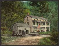
Escarpment Trail - Historic Hike - Approximately 6.39 miles round trip - 3 hours. Easy. This hike will encounter Kaaterskill Falls, Laurel House, Kaaterskill Hotel site, Boulder Rock, Catskill Mountain House, and the Saw Mill. Numerous other landmarks. Boulder Rock and the old Catskill Mountain House provide outstanding views of the Hudson Valley. You can make side trips to North-South Lake for bathrooms, picnicing, fishing, etc.
|
|
| |
| |
|
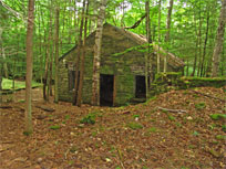
Harding Road Trail - 5.05 miles round trip - 3.5 hours. Easy hike. This hike will encounter the North/South lake, Kaaterskill Hotel Site, and the Harding Road Trail. The Harding Road was built for visitors to the Kaaterskill Hotel. It was considered an impossible road to build, but it was built at a high price.
|
|
| |
| |
|
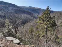
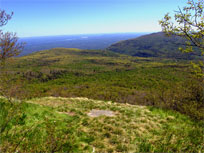
Huckberry Point - Approximately 4.5 mile round trip - 2-3 hours. Easy hike. Huckleberry Point has outstanding views south into the Hudson Valley, Platte Clove Valley, and Indian Head Mountain Range.
|
|
| |
| |
|
Kaaterskill Amphitheater and Hawkeye 7.55 miles - 5 hours round trip. Moderate climb. Follow one of the Mohawk Indian's old trails. This hike does require some BUSHWHACKING. This hike is best done when the leaves are NOT on the trees. Very remote hike with very few other hikers.

|
|
| |
| |
|
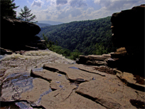
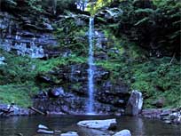
Kaaterskill Falls - 0.60 to 2.83 miles - 1-3 hours. Easy-to-moderate. Hike to bottom AND top of Kaaterskill Falls. Starts at Laural House Road for top of Falls. This is the MOST popular hike in The Catskill Mountains. It is best to hike after a large rain storm (4-5 inches).

|
|
| |
| |
|
Kaaterskill Rail Trail - 3.16 miles - 2-3 hours. Easy. Hike The Kaaterskill Rail Trail From the bottom of Laurel House Road to the Mountain Top Historical Society in Haines Falls. At the Haines Falls side you will get to see the Trail Station.
|
|
| |
| |
|
Kaaterskill High Peak (North Access from Platte Clove) - Approximately 8.23 mile round trip. Average 5 hours. 1775' vertical ascent. Easy except for last 600 vertical feet, which is difficult. Hurricane Ledge is 1/4 miles past the peak, and has outstanding views south into the Hudson Valley and Indian Head Mountain Range.


|
|
| |
| |
|
|
Kaaterskill High Peak (North Access from Palenville) - 16.24 mile round trip - 12 hours. Moderate climb (15%) for 3,075 vertical feet. Level hike next 3 miles. Moderate next 1.5 miles. Difficult climb for last 600 vertical feet. Hurricane Ledge is past the peak (outstanding views). Plane crash east of the summit.
|
|
| |
| |
|
|
Kaaterskill High Peak (South Access from Loop Trail) - Approximately 9 mile round trip - 4-5 hours. Easy except for last 600 vertical feet, which is difficult and dangerous. Hurricane Ledge is just below the peak, and has outstanding views south into the Hudson Valley and Indian Head Mountain Range.

|
|
| |
| |
|
|
Kaaterskill High Peak (West Access from Loop Trail) - Approximately 6.41 mile round trip. Average 5 hours. 1330' vertical ascent. Moderate hike. This is a BUSHWACK Hike! This hike also includes a visit to the Tory Fort in the saddle of Kaaterskill High Peak and Round Top Mountain. Hurricane Ledge is 1/4 miles past the peak, and has outstanding views.
|
|
| |
| |
|
|
Kaaterskill High Peak and Round Top Mountain (West Access from Loop Trail) - Approximately 8.16 mile round trip. Average 5 hours. 1330' vertical ascent. Difficult hike. This is a BUSHWHACK Hike! This hike also includes a visit to the Tory Fort in the saddle of Kaaterskill High Peak and Round Top Mountain. Hurricane Ledge is 1/4 miles past the peak, and has outstanding views.
|
|
| |
| |
|
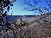
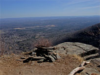
Palenville Overlook, and Indian Head Ledge - 8.12 miles round trip - 5 hours. Easy hike. This hike will encounter the North/South lake, Old Otis Cog Railway, Palenville Overlook, and Indian Head. Starting point is from the South Lake overflow area. Starting from Scutt Road will add another 2 miles to the hike.
|
|
| |
| |
|
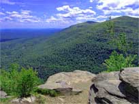
Poets Ledge 6.14 miles round trip - 4.5 hours round trip. Moderate climb (15% for 1.9 miles). Poet's Ledge has one of the most stunning views in the Catskill Mountains. Very remote hike with very few other hikers.
|
|
| |
| |
|
|
Poets Ledge & Hawkeye Ledge 7.96 miles round trip - 5 hours round trip. Moderate climb (15% for 1.9 miles). Poet's Ledge has one of the most stunning views in the Catskill Mountains. Hawkeye has a wonderful walk to the ledge. Hawkeye Ledge is now overgrown in the summer, but it is still a very nice hike. Very remote hike with very few other hikers.
|
|
| |
| |
|
Poet's Ledge & Viola, Wildcat, Buttermilk Waterfalls 9.68 miles round trip - 8 hours round trip. Moderate climb (15% for 1.9 miles). Poet's Ledge has one of the most stunning views in the Catskill Mountains. Nice level walk from the trail head to Poet's Ledge to the 3 water falls runs thru some spectacular old growth forest with some trees 3 feet in diameter. Very remote, with lots of wildlife.
|
|
| |
| |
|
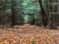
Sleepy Hollow Trail - Approximately 5.05 miles one-way - 3-4 hours. Easy. This hike is all down hill. You will get to see the historic Rip Van Winkle House site.
|
|
| |
| |
|
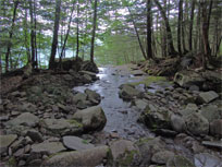
Upper Platte Clove & Upper Hells Hole Creek - Approximately 1-to-4 miles round trip - 2-3 hours. Moderate-to-difficult. Also dangerous - NOT for children! The Upper Platte Clove has three waterfalls. Two of the waterfalls are 70' and 90' high. Hells Hole Creek has three waterfalls.
|
|
| |
| |